
I remember arriving at dawn, the air cool and strange, and feeling like I had stepped into a place both ancient and alive.
My guide began as a personal deep dive into canary islands volcanic landscapes, a slow search for raw terrain and quiet corners away from crowded viewpoints.
I moved island by island, favoring sunrise and late-day windows to avoid heat and crowds and to watch how light revealed ochre rock, black soil vineyards, and fresh lava fields.
The pull was simple: volcanoes sculpted by fire, ridgelines that felt cinematic, and human touches—Manrique’s art, vine rows in ash—that made each stop more than a view.
I kept the pace slow, balanced must-see icons with lesser-known routes, and focused on practical tips for access, safety, and gear so your own trip feels effortless and respectful of this living terrain.
Key Takeaways
- This is a first-person guide to offbeat geologic sites across the island chain.
- Expect varied surfaces—ash, jagged rock, cooled lava—and plan footwear and timing.
- Balance iconic stops with quiet corners; aim for sunrise or late day.
- Learn practical access, safety, and transport tips for each destination.
- Respect the living landscape and local stewardship while exploring.
Why I’m Drawn to the Canary Islands’ Otherworldly Volcanic Landscapes
I kept returning to this archipelago because each day felt like a new scene from a world shaped by fire and wind.
The textures here are immediate: cooled lava, ash flats, and wind-cut ridges that change with light. Those shifting views made me spend long hours outside, hiking at dawn and lingering until sunset.
Mount Teide towers at 3,718 meters and you can reach its heights by cable car or on foot. Between April and June the slopes bloom, a soft surprise against raw rock. That contrast—giant peak and tiny flowers—pulled me back repeatedly.
I felt at home in the rhythm of early starts and late golden light. The island’s easy access to trails and viewpoints let me follow curiosity without rigid plans.
“The same ridge looked like a different world when clouds rolled in; I learned to return rather than tick a box.”
I wanted to see how people lived with this terrain—vine terraces, small villages, and art that blends with stone. Those human touches made the place feel lived-in, not distant.
- I was captivated by scale and intimacy—a looming volcano beside fragile alpine blooms.
- The climate here feels like eternal spring, so visits can work in any season.
- Simple drives and short hikes made exploration feel effortless and rewarding.
Canary Islands volcanic landscapes: where I find raw beauty beyond the crowds
I chased quiet: out-of-the-way flats, hidden craters, and wind-swept beaches that felt like their own worlds.
Hidden gems that feel a world away from resort strips
I prioritized quiet corners on each island, seeking malpaís flats, caldera rims, and tucked-away sites that shifted me far from resort energy in just a short drive.
Lanzarote’s interior malpaís fields are vast and stark, while the south holds the resorts. Famara Beach stayed refreshingly undeveloped, with campervans, dunes, and surfers beneath dark peaks.
Choosing trails and sites that reward curiosity
I cherry-picked a trail when a loop or out-and-back promised big texture changes—cinders to lava slabs to soft sand—without a full-day commitment.
- I mixed short walking routes with one longer hiking push per area to notice small details.
- I used map checks to spot dead-end lava roads and parking pockets that eased access to lesser-known sites.
- Notes from gran canaria helped me judge crowd levels and terrain contrasts across the archipelago.
Timing mattered: sunrise or late afternoon reclaimed stillness and made each destination feel like a personal discovery.
Lanzarote off the beaten path: Timanfaya, malpaís, and moonlike ridgelines
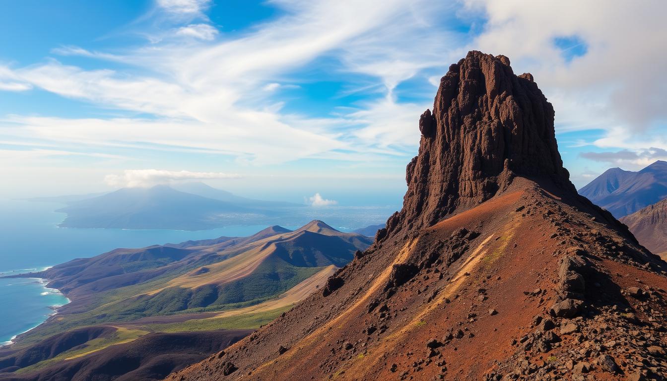
I chose to start my day where rock and heat still tell the story of an island reshaped by fire.
Sparse, dramatic terrain defines this stretch: ochre cones, black fields, and ridgelines that read like a natural stage. I moved slowly to soak in those views and to avoid the busiest circuits.
Timanfaya National Park and the Montañas del Fuego: geothermal theater and Martian vistas
I entered timanfaya national park early and watched staff pour water into vents until steam shot skyward. The guides and El Diablo restaurant make the park feel alive; you can see how eruptions from 1730–1736 layered the island with malpaís.
Caldera Blanca at sunrise: walking the rim of a young giant
I timed Caldera Blanca for sunrise and followed a short trail to the rim. At about 1,500 feet the view stretched across the island and to the Atlantic, a quiet way to start the day.
El Cuervo’s collapsed crater: stepping inside a volcano
El Cuervo is a partially collapsed cone you can walk into on a clear path. The crater floor is full of black stones and sparse shrubs, and my footsteps sounded loud in that still bowl.
- I balanced bus circuits in Timanfaya with self-guided loops outside core zones for both geothermal theater and personal discovery.
- I watched footing on lava slabs and loose ash, giving extra time even for short hikes.
- I left room for a picnic overlooking the Montañas del Fuego and let the silence become the highlight of the day.
Art into nature: how César Manrique reshaped the island experience
Walking through Manrique’s work felt like stepping into a museum grown from lava and sea air.
César Manrique fused art and geology to make public spaces that read like extensions of the terrain. His projects frame views, slow movement, and invite lingering. I moved from one designed site to raw rock and watched each place deepen my sense of home on this destination.
Jameos del Agua and Cueva de los Verdes
I entered a lava tube turned cultural space and found foliage, a bar, and an amphitheater nested around a luminous lake. The tiny blind albino crabs at Jameos del Agua feel like a local curiosity that ties nature to culture.
Cueva de los Verdes stretches for about a mile of walkable tunnel. Its soaring chambers show how a volcano’s force became a site for calm and sound.
Mirador del Río and LagOmar
From Mirador del Río I watched the sea frame distant islets. The viewpoint sits lightly on the cliff, never overwhelming the view.
LagOmar reads as architecture carved into slope. Pathways and courtyards feel grown from rock rather than placed on it.
Punta Mujeres’ pools and village calm
Punta Mujeres offered a quieter rhythm. Natural seawater pools and a small bar called La Piscina gave me a reason to slow down and taste local dishes.
| Site | Type | Highlight | Why visit |
|---|---|---|---|
| Jameos del Agua | Lava tube cultural space | Luminous lake & albino crabs | Unique fusion of art and nature |
| Cueva de los Verdes | Walkable tunnel | Long subterranean chambers | Quiet, dramatic geology made accessible |
| Mirador del Río | Clifftop viewpoint | Panorama of the sea and archipelago | Architecture that frames views |
| LagOmar | Residence & public spaces | Cavernous courtyards and terraces | Sculpted living spaces in rock |
- I saw how design can reveal the island’s forms rather than mask them.
- Moving between art and raw terrain taught me to read subtle details—curves, windows, and frames that echo the earth.
Wine, salt, and wind: Lanzarote’s landscapes put to work
On one slow morning I traced how people coax life from black ash and wind, and it felt like visiting a living laboratory.
I wandered La Geria to see picón in action: each vine sits in a conical hollow cut into volcanic ash, protected by a semicircular stone wall. The ash traps moisture from the air and lets Malvasía Volcánica survive where soil is thin.
Some vines are over 200 years old, and only about 10% of the wine leaves the island. I visited a small bodega and tasted wines that tasted of bright fruit and mineral edge. The experience felt intimate and rooted in place.

Salt flats and aloe: practical beauty in black rock country
I split the day between La Geria and the historic east-coast salt flats, where seawater has evaporated into salt since 1895. Pale pyramids of salt sat against black rock and wind-sculpted ridge.
The north surprised me with Europe’s largest organic aloe vera plantation. It felt like one more clever use of tough ground, an ongoing activity that turns hardship into harvest.
“Watching water disappear into salt felt like watching a very old trade keep time with the wind.”
- I photographed rows of stone walls and the texture of picón underfoot.
- I learned how ash and wind shape a glass of wine, and how craft keeps a day’s work tied to place.
Tenerife’s high country: chasing altitude and color on Mount Teide
I found the high country around Mount Teide to be a classroom in altitude and light.
Mount Teide rises to 3,718 meters, about 2,000 meters taller than other European peaks. The national park feels vast and exposed. I balanced speed and slow observation to get the most from the day.
Cable car vs trails: my approach to reaching Teide’s heights
I weighed the cable car’s quick lift against longer trails and chose both. A cable car ride eased altitude and gave me time to acclimate.
Then I hiked to savor color shifts and silence. I planned my summit push for cooler hours, moved steadily, and stopped often for photos and water.
Mirador Pico Viejo and La Fortaleza: craters, red rock, and the blue ocean
Mirador Pico Viejo looks onto an almost 800‑meter crater and gives sweeping views back to Teide and the ocean. La Fortaleza offered red rock contrasts and glimpses of the Orotava pines.
- Timing: visit April–June to catch the best spring bloom.
- Gear: layers, water, and respect for closures and signs.
- Note: the island’s thinner air changes temperature and wind quickly.
La Palma’s Cumbre Vieja: witnessing a transformed landscape
On La Palma, a single eruption rewrote shorelines and left a new grammar of stone I wanted to read on foot.
I came to see how a 2021 eruption changed the map. The volcano sent lava that cooled into fresh land, and I spent hours tracing the flows.
The cooled fields felt stark and hopeful. Black sheets of rock broke into islands of surviving green. New lines showed where molten rivers once ran.
Walking and biking the cooled lava fields
I followed a marked trail and kept my pace conservative, watching footing on rough textures and honoring closures. The national park signage explained how the event progressed and why some zones stay fragile.
Biking routes proved steep and demanding, so I chose short reconnaissance rides and longer walking windows to study flow patterns. I planned a flexible day with weather buffers because wind and heat change effort quickly on open rock.
I left with a deep respect for the island’s resilience; volcanoes shape not only land but memory.
- I treated the route like a slow study, not a checklist.
- I used maps, stayed on the trail, and gave quiet hours to the place.
When I go, what I pack, and how I get around
Packing and planning mattered more than I first thought. The weather felt like “eternal spring” most months, but summer spikes sometimes climbed toward 30–40°C. I planned each day around cooler starts and late afternoons to keep heat manageable.
Climate and seasons
The islands work year‑round for visits, yet altitude changes temperature fast. Mornings on high trails felt crisp while coastal stretches warmed quickly. I checked forecasts and picked activity windows with lower wind and clearer skies.
Gear checklist for trails
- Shoes: sturdy walking shoes with good traction.
- Layers: breathable shirts, a wind shell, and a warm midlayer for altitude shifts.
- Sun & hydration: brimmed hat, high‑SPF sunscreen, and at least 2 liters of water for a long day.
- Extras: light gloves for rough lava, a headlamp for early starts, a small first‑aid kit, and electrolytes.
Getting around: car vs bus
I rented a car for flexibility and early sunrise runs, stashing a cooler and extra layers in the trunk. Buses worked well for straightforward hops between popular nodes when parking was tight, but a car let me pivot quickly between coastal and high country on the same trip.
Keep plans loose: rest after big elevation days and swap to a coastal stroll if wind or heat picks up.
My sample itineraries for hikers, walkers, and curious road-trippers
My sample itineraries pack clear mornings, slow lunches, and golden-hour views into short, easy loops.
Two-day Lanzarote loop: Timanfaya, La Geria tastings, and a Famara sunset
I keep each day compact so walking and short drives feel restful, not rushed.
Day 1: sunrise at Caldera Blanca; mid-morning timanfaya national park bus loop with the El Diablo geothermal demo; afternoon La Geria tastings of Malvasía Volcánica; finish with a Famara sunset where waves meet cliffs and dunes.
Day 2: stroll Punta Mujeres’ pools in the morning, late-morning Jameos del Agua, early-afternoon Cueva de los Verdes, and golden-hour returns to malpaís viewpoints for photos.
Long weekend combo: Teide high trails and Lanzarote’s lava tubes
For a longer loop I flew into Tenerife South and drove to Teide base the first evening.
The next morning I rode the cable car, took a short hiking spur for near-summit vistas, and allowed time to acclimate before descending.
That afternoon I transferred to Lanzarote and enjoyed an evening walk near Jameos del Agua.
“I kept drives short, used village cafes as reset points, and always built weather buffers for ocean fog or high-country gusts.”
| Itinerary | Key stops | Highlights |
|---|---|---|
| Two-day Lanzarote | Caldera Blanca · Timanfaya National · La Geria · Famara | Geothermal demo · Wine tasting · Sunset surf |
| Long weekend combo | Teide cable car · Mirador Pico Viejo · Jameos · Cueva | Near-summit views · crater panoramas · lava-tube visits |
| Pacing tips | Short drives · Village cafes | Weather buffers · Flexible exits |
- I used food stops at bodegas and village cafes to reset energy between hiking blocks.
- I balanced headline volcanoes with quieter corners so each segment felt fresh.
- Always allow buffer time for transfers by ferry or flight when moving between each island.
Responsible travel on fragile rock: safety and stewardship
I treated each route as a study in patience—small choices preserve big places.
Trail etiquette matters here because the ground heals slowly. In Timanfaya, core areas are limited to the guided bus route, and staff use water to trigger steam demos from subsurface heat. Elsewhere, Teide access can change by route and weather, and La Palma now has new cooled flows with steep cycling sections and marked walking zones inside Cumbre Vieja National Park.
Trail etiquette on lava and crater rims
I stayed on marked trails and avoided stepping on fragile lichens, crusts, and tube edges. Moving rocks or stacking cairns can mislead hikers and damage sensitive features.
I kept sound low in caves and lava tubes and carried out everything I brought in. Parking only in designated areas minimizes harm to soils and rare plants near access points.
Water, timing, and respecting closures in national parks
I always packed at least 2 liters of water and wore sun protection. Dark ground reflects heat, so I built shorter midday segments and chose cooler windows for longer hikes.
- I accepted park closures without argument; management helps keep visitors safe around an active volcano.
- I timed visits to reduce crowding and strain on narrow pinch points.
- I supported local guides and visitor centers to learn current conditions and back conservation efforts.
Small acts—staying on the path, carrying water, listening to rangers—help these raw places last for future visitors.
Conclusion
The last morning I walked a crater rim at dawn and felt how light and wind set the day’s pace across sea and stone.
I left convinced that volcanoes shape more than scenery; they set rhythm, color, and the small rules for when to move and when to pause. Caldera Blanca and El Cuervo showed recent forms, while Manrique’s Mirador del Río frames the Chinijo Archipelago from a crafted perch.
Each island spoke differently—Lanzarote’s ash and design, Tenerife’s height, La Palma’s new ground—and gran canaria helped sharpen those comparisons. My best moments came when I slowed, let the wind write the soundtrack, and watched the sea catch first light from a crater rim.
Use this guide to plan thoughtfully: arrive early, tread lightly, and seek the quiet corners where a warm rock under your hand will feel like home.
Lascia un commento