
I still remember the first time I slipped away from the crowded city streets and found a quiet cliff path where the sea met sky. That moment changed how I travel.
In this guide I focus on calm regions and scenic routes that blend culture, landscapes, and small-city charm. I write for readers who want a travel experience that slows down time and favors beauty over busy beaches.
I map a practical flow from northern coasts to inland highlands and island trails. I pair hikes with old towns and local markets, so evenings feel as rich as daytime views.
Expect clear tips on access, crowd levels, and where to park near trailheads. I flag must-see gems and quiet places so you can choose the right destination for your pace.
Key Takeaways
- I guide you to lesser-visited gems that mix landscapes and culture.
- Practical tips cover timing, access, and pairing nature with city evenings.
- Regions range from rugged northern coasts to volcanic islands.
- This first-person guide is designed for U.S. travelers seeking authentic experiences.
- Each entry highlights views, crowd levels, and travel logistics.
The way I find Spain’s hidden nature: off the tourist track, big rewards
My research starts with regions that tourists often pass by, then I layer in local towns and trails.
I look for quieter corridors in northern coasts and the interior where crowds are lighter. I plot a practical trip that pairs a nature-first spot with a nearby town for food and sleep.
Timing matters: I hike at dawn or late afternoon to avoid buses and to catch golden-hour views. That short time window makes cliffs and gorges feel cinematic.
- I vet adventure potential: trails, viewpoints, and wildlife versus drive time and access.
- I use local maps, park sites, and visitor centers to tweak routes when weather changes.
- I cluster places into road loops to cut backtracking and keep each day efficient.
“If a cliff path is windy, I swap to a forest trail or lake ramble.”
I save offline maps and pins, keep a shortlist of quieter beaches and dramatic overlooks, and choose towns rich in culture so evenings feel as rewarding as daytime hikes. These tactics reveal real gems without the crowds.
Asturias’ coastal charm: quiet fishing villages, sea views, and secret beaches
I follow a coast road where quiet harbors and cliff paths reveal the region’s slow rhythm. This stretch rewards slow travel: bright harbors, clifflookouts, and towns that invite lingering.
Cudillero: hillside houses, harbor views, and seafood paradise
Cudillero feels like an amphitheater of colorful houses tumbling toward a natural harbor. I time my arrival to wander narrow streets and soak up harbor views before a seafood lunch.
Tip: Visit the 16th-century Church of San Pedro and pick a seaside restaurant for fresh catch of the day.
Muros de Nalón to Playa de Aguilar: colorful port, coves, and cliffside paths
From Muros de Nalón I take an easy coastal drive to Playa de Aguilar. Cliffside paths reveal coves and long views—ideal for a calm afternoon walk.
I also poke into old streets to read the town’s history and admire local architecture near the estuary.
Ribadesella: sandy beaches and a UNESCO-linked prehistoric cave
Ribadesella sits at the Sella River mouth with broad sandy beaches and a lively promenade. I pair a stroll with a planned visit to Tito Bustillo Cave to connect beach time with prehistoric culture.
“I park at the edge of town centers to stroll slowly and hit viewpoints at golden hour.”
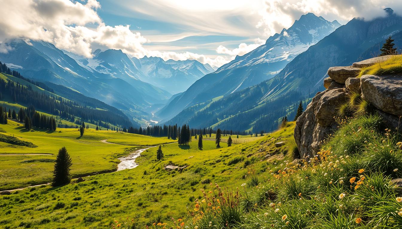
Picos de Europa: dramatic mountains, gorge hikes, and wildlife without the crowds
I wake before dawn to drive into jagged peaks that feel a world away from the coast. I base myself in a nearby town, then push higher early to own the valleys and maximize quiet time on the trails.
Ruta del Cares: cliff-cut trail with jaw-dropping views
The Ruta del Cares runs about 12 miles through a carved gorge. I start before most hikers to catch the best views and to keep the route feeling like an adventure.
I carry layers, water, and snacks because weather and wind change fast. I also note tunnel-cut ledges and river bends as calm photographic gems.
Caves and karst: Cueva del Soplao and 6,500+ caverns
Picos has over 6,500 caves and dramatic karst features. For a cave day I prebook timed entries at Cueva del Soplao to avoid queues and enjoy the stalactite displays.
- Wildlife: I bring binoculars to spot chamois, griffon vultures, and golden eagles while keeping a respectful distance.
- Timing: I track turnaround time so I’m off trails well before dark and pack rain gear even on clear mornings.
- Balance: Big hikes get mixed with short overlooks and village meals so the day ends with local dishes, not fatigue.
“Starting early and using minor trailheads preserves the sense of discovery here.”
The park’s long conservation history gives these landscapes an enduring character. I treat fragile paths lightly, and I sometimes pair a morning beach view with an afternoon peak when weather allows.
Somiedo Natural Park: biosphere reserve beauty and brown bear country
Somiedo Natural Park rewards patient travelers with wide skies and guarded wildlife. This UNESCO biosphere in the country mixes rugged mountains, lakes, and forests. The plain views hold an honest kind of beauty you feel more than name.
I plan each day to shape the experience. Trails run from easy lakeside walks to steep ridge routes. I switch routes if weather turns and I save tougher hikes for stable days.
- Wildlife: Brown bears, wolves, and golden eagles are present, so I keep distance and stay ethical in viewing.
- Low impact: I sometimes choose a guided horseback ride to see meadows without heavy footprints.
- Timing: I go early to beat crowds and pack layers for fast mountain weather.
“I bundle Somiedo with nearby towns for dinner, then return at first light for the best chance of sightings.”
| Trail Type | Difficulty | Best Time |
|---|---|---|
| Lakeside loop | Easy | Morning |
| Ridge viewpoint | Moderate | Late afternoon |
| High pass | Challenging | Stable weather days |
I support local stewardship by staying in small lodging and eating in nearby towns. The park’s biosphere status ties conservation to daily life and local history. I carry a simple wildlife checklist to enjoy the scene even when big sightings stay secret.
Basque Coast wonders: flysch cliffs, islands, and cinematic landscapes
A stretch of dramatic coast folds geology into cinematic views that reward slow travel. I spend a day here letting rock layers and sea light set the pace.
Zumaia Geopark: UNESCO-recognized geology and the Flysch Path
The Zumaia Geopark runs about 8 km and exposes rock layers from the Triassic onward. I walk the Flysch Path at mid to low tide for the clearest exposures and wide views.
I often add a boat tour when conditions permit. From the water the strata’s colors and angles really pop.
San Juan de Gaztelugatxe: hermitage views and crashing sea
The hermitage sits on a rugged islet reached by a stone bridge and 241 steps. I book a reservation in advance and aim for a weekday morning when the climb feels quieter.
Fun fact: Gaztelugatxe doubled as Dragonstone on Game of Thrones, which adds a cinematic layer to the place.
- I pack grippy shoes, sun protection, and extra water for exposed shore walks.
- I link the coast to nearby cities like Bilbao or San Sebastián for meals and museums, then return for sunset light.
- I check tides and swell and use inland lookouts when seas run high.
| Feature | Zumaia | Gaztelugatxe |
|---|---|---|
| Primary draw | Flysch geology | Historic hermitage & views |
| Best time | Mid–low tide, afternoon light | Weekday morning (reserve) |
| Access | Coastal path, boat tours | Stone bridge, 241 steps |
| Tip | Use less-trafficked access points | Pace the climb; photograph side light |
“I photograph the land-sea interplay from headlands above Zumaia, aiming for side light that reveals textures in the flysch.”
Valderejo Natural Park: Purón River canyon and Basque highland solitude
Walking beneath 700-meter cliffs in Valderejo makes the everyday world feel small and distant. I come for the canyon scale and the hush that holds the valley.
I plan a circuit from Las Lastras to Ribera, then climb to Santa Ana for a high panorama. Trails thread the gorge and reveal limestone walls that tower above the river.
Wildlife is a main draw: I use binoculars to scan for eagles, vultures, chamois, and otters at dawn. I stay quiet and keep distance to protect habitats.
- I wear sturdy shoes and pack a wind layer; canyon breezes can be strong.
- I carry extra water, a topo map, and expect spotty phone signal in parts of the park.
- I time photos for early or late light to catch shadow on the limestone faces.
I pair the hike with a simple village lunch, then stroll narrow streets and small squares that keep local charm. I watch for ancient settlements and burial sites and stay on marked paths. I leave no trace and keep noise low so the park’s quiet can feel like its own small world.
“I tread quietly along streams where otters might slip by at dawn.”
Navarra’s wild side: semi-desert to primeval forests
I spend a day in Navarra moving from stark badlands to deep, mossy woods. The region rewards contrast: wide, ochre plains and a cathedral-like beech-fir canopy sit within short driving time.
Bardenas Reales: otherworldly badlands and wide-open landscapes
In Bardenas Reales the land feels lunar—hoodoos, eroded ridges, and long dirt roads open to the sky. I go early to catch cool air and low-angle light that sculpts the cliffs.
Practical tip: bring water, sun protection, and a hat. Services are scarce and the semi-desert is exposed. I stick to designated tracks and avoid fragile crusts.
“Parts of Game of Thrones were filmed here, but I prefer to drive slowly and stop for quiet photos.”
Irati Forest: beech-fir canopy and blazing fall colors
Irati feels like a different world—dense beech and fir lanes, streams, and long green corridors that glow in autumn. I pack layers because the shade brings cool, damp air.
I split my Navarra days: one for Bardenas’ eerie light, one for Irati’s hushed trails. I pair those outings with a cultural evening in Elizondo, a small town where Basque culture and riverside restaurants add warmth after a day outdoors.
- I time visits for weekdays to keep silence and space.
- I check seasonal road and access conditions, especially in fall.
- I treat both places with respect—stay on marked routes and carry out trash.
Pyrenean basecamps: medieval towns wrapped in nature
I choose medieval bases where stone squares lead directly to mountain trailheads. They make early starts easy and allow relaxed evenings in town.
Aínsa: stone squares, river views, and trails to Ordesa y Monte Perdido
Aínsa sits as a practical base for hikes into Ordesa y Monte Perdido and Sierra de Guara. I wander the old town at dusk to enjoy quiet streets and a sense of history.
Tip: I rise early to reach trailheads and alternate big mountain days with gentler river walks to save energy for classic lookouts.
Elizondo & the Baztan Valley: green hills, caves, and Basque traditions
Elizondo anchors the Baztan Valley with green lanes and Basque charm. I add a visit to Zugarramurdi to link cave folklore and geology with village life.
I scout parking and shuttle options, pack picnic basics for hilltop lunches, and return to town for simple dinners and calm evening strolls.
“I balance high ridge days with softer valley walks so each morning feels fresh.”
| Base | Primary draw | Best day plan |
|---|---|---|
| Aínsa | Medieval architecture & mountain access | Morning trailhead, afternoon river views |
| Elizondo | Baztan valley charm & Basque culture | Valley walk, cave visit at midday |
| Zugarramurdi | Caves & witchcraft museum | Short geology tour, folklore stops |
Western Spain’s quiet treasures: history, old towns, and protected landscapes
I slow my pace in the west, letting medieval lanes and upland cliffs set the day’s rhythm.
Cáceres old town: UNESCO World Heritage walls and stargazing escapes
I base myself near the old town to wander stone lanes and plazas after morning hikes. Cáceres is a unesco world heritage place where Roman, Arab, and Christian layers meet in tight streets.
I time a late lunch, then return to the walls and towers for evening light and photographs. I leave space for small museums and quiet churches to round out the cultural experience.
Monfragüe National Park: raptor-rich skies and Tagus River cliffs
For a day in the park I focus on lookouts where griffon vultures and eagles patrol the cliffs over the Tagus. I pick short hikes and keep binoculars ready for birdwatching and wide views.
“I visit in shoulder season for milder temps and quieter trails.”
- Practical: watch advisories, carry water in hot months, and respect wildlife distance.
- Loop tip: add a rural inn or small town overnight to break drives and linger.
| Site | Primary draw | Best plan |
|---|---|---|
| Cáceres | Historic walls & plazas | Late lunch, evening stroll |
| Monfragüe | Raptors & Tagus cliffs | Morning lookout, afternoon hike |
| Nearby town | Rural inns | Overnight rest between drives |
Castilla y León countryside: villages, views, and time-worn charm
I steer inland to quiet lowland villages where stone streets and wooden balconies feel paused in time. The region rewards a slow pace: mornings for short hikes, afternoons for plaza-side coffee, and evenings in narrow lanes.
La Alberca: half-timbered beauty and Sierra de Francia hikes
I point my car to La Alberca’s half-timbered lanes and the Plaza Mayor with its 18th-century town hall arcade. I time strolls for early morning when the streets are hushed and architectural details stand out.
Trail tip: Lace up for Sierra de Francia hikes and nearby waterfalls right from the village edge. I savor local dishes—black pudding and honey desserts—before sunset walks to viewpoints above the countryside.
Zamora and the Duero: Romanesque skyline and stone bridges
I fold Zamora into the route for its dense Romanesque churches and the slow walk across the 13th-century Puente de Piedra over the Duero. I step into the cathedral and explore castle ruins for a compact dive into regional history.
I photograph façades and carved capitals around the old town, appreciating layers of architecture without big-city rush. I schedule a culture-first day for churches and museums, then interleave a nature day in nearby hills and rivers.
- I pick small inns or family-run stays for a warm blend of local charm and easy evening strolls.
- I carry a light jacket for breezy riverfront walks and pack a day bag for short hill hikes.
- This leg links well to western routes or loops back north, keeping drives scenic and relaxed—perfect for finding quiet gems and deeper culture.
“I photograph façades and capitals around town, appreciating the layers of architecture without the rush of big-city crowds.”
Andalusia’s adventure corridor: cliffs, canyons, and mountain forests
This stretch of Andalusia rewards a car-based trip that links dramatic cliffs to deep, shaded woods.
I start at Caminito del Rey, booking tickets ahead and taking an early slot to beat crowds and heat.
Caminito del Rey: sky-high boardwalks over Gaitanes Gorge
The boardwalk clings to limestone walls and offers theatrical canyon views. I wear grippy shoes and carry a light wind layer because gusts can surprise you.
Sierras de Cazorla, Segura y Las Villas: waterfalls, wildlife, and pine oceans
From Málaga I drive inland to Cazorla’s mountains. Trails run from river canyons and cascades to long pine corridors that feel like oceans of trees.
I base in small towns to shorten drives between trailheads. I photograph overlooks at morning or late day to reveal texture in rock faces and forest slopes.
I alternate longer hikes with scenic pullouts and picnic stops. I keep water and snacks handy; summer canyon heat demands planning and contingency shaded routes.
“I end each day with a relaxed dinner in a town square, recharging for the next mountain morning.”
Valencian uplands and blue pools: mountain villages by turquoise water
I leave the shore behind and follow ridge roads that open to cliff-top villages and bright reservoirs. The day works best as a short inland loop that trades beaches and sea views for highland air and quiet lanes.
First stop: Guadalest. I climb to overlooks above the turquoise reservoir and the Sierra de Aitana. From the mirador the village looks like a tiny gem perched over the water. I wander narrow streets, grab a simple lunch, and time a sunset lookout above the reservoir.
Guadalest: cliff-perched views over the reservoir
I pick calmer pullouts on the drive so the road itself becomes part of the destination. Small terraces and hidden benches make great photo stops.
Montanejos: thermal springs and river canyons
Later I drive north to Montanejos for the Fuente de los Baños hot springs. I aim for quieter hours and bring water shoes for rocky shallows. A soak in warm pools framed by canyon walls feels like a mountain paradise.
- I use my car to link villages and trailheads, arriving early to avoid crowds.
- I pack a small towel and layers; shaded river corridors cool fast.
- When time allows I add a second upland viewpoint to chase extra views before returning to nearby cities or the coast.
“Pair a light coastal morning with this inland day to balance your route and keep drives scenic.”
La Palma, Isla Bonita: volcanic peaks, black-sand beaches, and cosmic skies
I plan short, high-reward hikes that climb volcanic saddles and then drop toward black-sand coves. La Palma blends laurel forests, recent lava fields, and dramatic crater rims into a compact island journey.
My day often begins with a ridge-and-crater loop in Caldera de Taburiente. I pick trails that deliver sweeping island landscapes without long slogging. Midday I favor shaded forest rambles to cool off and change pace.
In late afternoon I head to a black-sand beach for a quiet swim as the light softens. I schedule night sky sessions at high viewpoints near the observatory to avoid town lights. Clear skies here make for some of the world’s best stargazing.
I watch the calima forecast and carry a headlamp for safe returns. I photograph early and late to capture shadow on cinder cones. Simple seaside dinners in small coastal towns round out the day.
“The island asks for flexibility—microclimates change fast, so I plan for plan B.”
spain nature hidden spots: how I plan a low-crowd, high-reward trip
I build each day around a main walk, a shorter pause, and a looped route that keeps driving scenic.
Best seasons and timing: beating peak hours and tour buses
Best seasons and timing: beating peak hours and tour buses
I pick shoulder months and weekdays to avoid crowds and coach schedules. I start hikes at sunrise when the light is best and the trails feel private.
I prebook timed entries for high-demand sites and keep a weather fallback ready. If a plan changes, I swap in a nearby village visit to save the day.
“Early starts and weekday plans turn busy highlights into quiet mornings.”
Car-based itineraries: connecting towns, parks, and viewpoints
Car-based itineraries: connecting towns, parks, and viewpoints
I use a car to link parks, small towns, and lookout points. I plot short loops to limit backtracking and keep driving legs under two hours when possible.
I park at the edge of old quarters, walk in for dinner, and sleep where streets feel calm. Offline maps and saved pins keep me on track without signal.

| Strategy | When to use | Typical drive time |
|---|---|---|
| Sunrise hero hike | Weekdays, shoulder season | Under 1.5 hours |
| Village culture stop | Late afternoon | 15–40 minutes |
| Reserve entry sites | Peak draws (book ahead) | Varies |
Conclusion
My final note: pick one great destination a day and give it time. I find this pace turns busy highlights into personal gems and cuts crowds from the experience.
Slow travel lets me link UNESCO world heritage sites, an old town’s streets, and dramatic views into one relaxed route. The mix of architecture, history, and landscapes proves the country’s beauty is as rich as its cultural heritage.
I travel by car, linger in small towns and villages, and finish days remembering favorite places. With flexible timing and a simple plan you can build your own hidden gems spain list and return ready to explore new regions year after year.
Lascia un commento