
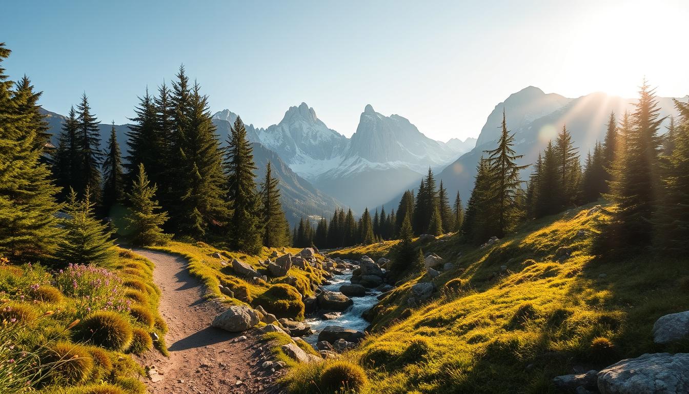
I come back to these ranges because they slow me down. Tucked between the Atlantic and the Mediterranean, this stretch of peaks and valleys lets me trade noise for quiet views and long, measured breaths.
I open this guide with what draws me here: beech forests, serrated ridgelines, and paths that feel like a walking holiday rather than a race. I use the phrase pyrenees hidden trails to mean less crowded corridors where the mountains set the pace.
I write in first person to share how I plan and linger. I outline options from coast-to-coast traverses and the big routes to compact hut circuits like carros foc, so you can match time and energy to an adventure that fits you.
Practical notes matter: huts, small inns, and simple logistics turn a dream into a doable trip. I will also stress safety and seasons up front so your plans stay realistic and rewarding.
Key Takeaways
- I write from personal experience to help you plan a memorable walking holiday.
- Expect varied terrain, reliable huts, and a balance of solitude and safety.
- Options range from long traverses to week-long hut circuits and day hikes.
- I preview routes and practical details like days, distances, and season windows.
- Respect nature and local culture; pause often to make lasting memories.
Why I chase the Pyrenees’ quiet lines between the Atlantic and the Mediterranean
A day here can move from damp beech shade to wind-washed summits, and I crave that change. The contrast keeps me alert. It also makes planning a walking holiday feel more like choosing moods than forcing miles.
The wild diversity: forests, ridgelines, and glacier-carved valleys
In the french pyrenees a single morning can start under dripping beech leaves and end on a high shoulder with far-reaching views.
Glaciated bowls, slot canyons, balcony paths, and broad plateaus give every hike a fresh rhythm. I count on village inns and refuges when I push a long day, so logistics stay humane.
Finding solitude beyond the spotlighted Alps
Fewer resorts and cable cars means more room to breathe. I read the weather each morning: if clouds gather I pick forest routes; when skies clear I aim for ridgelines.
I split objectives—pairing a scenic half-day with a longer outing—to stay energized. Often the best views come after a quiet climb, when the world drops away and only wind and marmots share the moment.
| Feature | Why it matters | How I use it |
|---|---|---|
| Varied terrain | Keeps energy and interest up | Mix short and long hikes in one day |
| Simple huts & inns | Reliable food and rest | Push a big day, sleep well afterward |
| Lower crowds | Quieter access to views | Choose ridgelines for sunrise solitude |
How I map the range: western green waves, central giants, eastern sunlit ridges
I plan every route by laying a paper map flat and tracing the range from west to east. That simple act sets my direction and shows how the whole range forms a bold line between the Atlantic and the coast.
Western slopes: beech woods, misty mornings, Atlantic breezes
I note the western side first. Damp beech forests and low cloud shape gentler hiking here.
The trail profiles feel softer. I often pick this direction when I want green over granite.
Central high country: Aneto, Ordesa canyons, big passes and bigger views
Next I trace the central mountains. Peaks like Aneto demand bigger vertical gains and longer passes.
I expect sharper relief, deep canyons, and weather that can change fast. I add margin in my plan.
Eastern horizons: warmer, drier ridgelines leaning toward Catalonia and the coast
The eastern reaches give drier air and long ridges that lean toward Catalonia and the Mediterranean.
I mark Carros Foc as a compact, hut-linked circuit on my map when time is tight.
| Zone | Character | Key route |
|---|---|---|
| West | Beech, mist, gentler grades | GR 10 (French side) |
| Central | High peaks, deep canyons, storm margin | GR 11 / HRP access |
| East | Dry ridges, long views, water planning | Carros Foc circuit |
Pyrenees hidden trails: my shortlist for true nature lovers
When I choose a route, I hunt for quiet lines that feel like a personal invitation. I list the options I return to or recommend when hikers ask for real nature and fewer crowds.
Coast-to-coast classics: GR 10 (875 km, 45–60 days) and GR 11 (840 km, 50–60 days) suit a life-list trip. The HRP (about 800 km, 50–60 days) is the high, border line for a bolder push.
Week-long hut circuits: Carros de Foc (65 km, 6–7 days) and Cavalls del Vent (84 km, 3–5 days) give a hut-to-hut rhythm and manageable logistics for a short adventure.
Shorter loops and cultural walks: Alta Ruta de los Perdidos (~100 km, ~7 days) and Ruta de las Golondrinas (74 km, ~6 days) trade fame for local flavor and varied landscapes.
| Route | Distance | Days | Best fit |
|---|---|---|---|
| GR 10 | 875 km | 45–60 | Coast-to-coast, lush valleys |
| GR 11 | 840 km | 50–60 | Warmer, rugged Spanish side |
| HRP | 800 km | 50–60 | High, exposed border line |
| Carros de Foc | 65 km | 6–7 | Hut circuit, lakes and granite |
| Cavalls del Vent | 84 km | 3–5 | Refuge network, quick week |
| Alta Ruta de los Perdidos | ≈100 km | ~7 | High country, stretch adventure |
| Ruta de las Golondrinas | 74 km | ~6 | Cultural loop, quieter days |
I note likely start towns and refuge density when you plan, and flag which walks suit a first hut trip versus those that demand more fitness and route sense. Circle one for your next trip and star another to save for later.
GR 10 on the French Pyrenees side: a coast-to-coast dream broken into wild sections
I plan the GR 10 as a sequence of short chapters—village mornings, high passes, and quiet evening refuges. That way I can slice a long distance into manageable days and still feel the full mountain rhythm.
What I love about the GR 10 experience
- I like how the trail links village comforts and wild passes so I can break the dream into sections when time is tight.
- I plan days by terrain rather than pure kilometers; elevation and weather shape my hours more than flat distance.
- I carry a light hut kit and rely on refuges, gîtes, and small inns for accommodation and hot meals.
Fast facts: distance, days, elevation, timing, nearby towns
| Item | Detail | Notes |
|---|---|---|
| Distance | ≈866–875 km | Hendaye to Banyuls-sur-Mer |
| Typical days | 45–60 days | Can be broken into shorter sections |
| Elevation gain | ≈48,000–50,000 m | Variable daily climbs; plan rest days |
| Best time | June–September | Western/eastern starts sometimes earlier |
| Nearby towns | Cauterets, Luz-Saint-Sauveur, Luchon | Great for resupply and accommodation |
Hidden-feel highlights I return to
I savor the Cirque de Gavarnie’s walls, the glacier views near Vignemale from Refuge Bayssellance, and the cascade into Lac d’Oô. These moments feel remote even on a well-marked route.
Practical notes: water is reliable in many segments but I still plan refills. I start high passes early to avoid afternoon storms and budget flexible accommodation—one hot meal and a bunk can make the hardest hours feel simple.
GR 11 Senda Pirenaica: the warmer Spanish traverse with rugged character
I favor the GR 11 when I want sun-baked ridges and a rougher, more open underfoot feel. This route runs mostly on the Spanish side and often feels raw and exposed compared with the western green lines.
Why it feels raw and exposed
Open slopes and long hours above treeline make the GR 11 a sunlit, grinder-style trail. Expect pine shade to give way to rocky runs and strong light that can sap energy faster than the distance suggests.
I plan earlier starts and longer water carries. I also watch weather closely and time passes for the coolest hours to avoid afternoon storms and heat.
Fast facts: distance, days, elevation, timing, nearby towns
| Item | Detail | Notes |
|---|---|---|
| Distance | ≈840 km | Cape Higuer to Cap de Creus |
| Typical days | 50–60 days | Plan rest and resupply |
| Elevation gain | ≈39,000 m | Stronger sun and exposure |
| Best time | Mid‑July to mid‑September | Carry layers for sudden weather |
| Nearby towns | Hondarribia, Parzán, Setcases | Good for resupply and towns |
Must-see national park segments: Ordesa and Aigüestortes i Estany de Sant Maurici
I mark Ordesa y Monte Perdido and Aigüestortes estany sant maurici as highlights. Both parks open high basins, serrated peaks, and dramatic cascades that change the route’s mood.
- I stage resupplies and short rest days near access towns to keep my pack light.
- I talk with other hikers for live info on water and snow near high passes.
- Many of the best hours come when I walk alone, wind and vulture for company.
Why this line sticks with me: it feels like walking a country’s spine — sun, stone, and long mountain hours that stay with you long after the hike ends.
HRP high route: straddling the border on the wildest line
I seek the highest ridge lines when I want a trip that feels truly remote.
The HRP follows the crest for roughly 800 km and asks for steady judgment. I choose it when I want a wilder mountain feel and fewer people.
Who this adventure is for and why navigation matters
I recommend this route for experienced hikers who read maps well and accept variable conditions. Navigation is key: I carry paper maps, note exit points, and check weather every morning.
Fast facts
| Item | Detail | Notes |
|---|---|---|
| Distance | ≈800 km | High crest line between France and Spain |
| Typical days | 50–60 days | Plan rest and flexible legs |
| Elevation gain | ≈52,000 m | Plan by elevation profile, not only distance |
| Best time / resupply | mid‑June to mid‑September | Conservative resupply points; huts vary |
I mark huts like Refuge Bayssellance as lifesaving on bad days. I plan days by water and elevation and expect snow patches on early-season crossings.
The quiet of Ibón de Estanés and the blue of Ibones Azules repay the effort. Pick this line if you smile at complex maps and endless horizons.
Carros de Foc in Aigüestortes i Estany de Sant Maurici National Park
A compact, high-loop circuit like Carros de Foc lets me condense mountain time into a week of lakes and granite passes.
The hut-to-hut rhythm: light packs, big lakes, granite passes
Carros de Foc is a 65 km circular route that I usually walk in 6–7 days. Huts are well run, so I carry a light pack and book early in mid‑July to mid‑September.
I move from basin to basin, crossing granite passes and finding more than 30 small lakes along the way. Refuges like Ernest Mallafré, Restanca, and Ventosa i Calvell make sensible start and exit points.
Fast facts: distance, days, elevation, timing, common start points
Distance: 65 km. Elevation gain: ≈4,700 m. Best time: mid‑July to mid‑September. Access points: Refugi Ernest Mallafré, Refugi de Restanca, Refugi Ventosa i Calvell.

My sunrise memory at Refugi Josep Maria Blanc
I woke to glassy water, granite silhouettes, and a hush so complete I could hear my breath. That morning at Refugi Josep Maria Blanc is why I recommend this loop as a first multi-day hike that still feels properly high and wild.
Cavalls del Vent loop in Cadí-Moixeró: eight refuges and wind-brushed ridges
A good loop gives me long views without complicated logistics, and Cavalls del Vent does that well. The route links eight well-placed refuges so I can carry a light pack and still spend full days on the ridge.
Why this route balances wildness and access
I like this loop when I want a hut-linked route with real ridge views but easier logistics and multiple access points.
The terrain alternates shaded forest climbs, rocky passes, and long, view-forward traverses that keep the hike engaging.
Fast facts: distance, days, elevation, timing, nearby towns
| Item | Detail | Notes |
|---|---|---|
| Distance | ≈84 km | Loop across Cadí-Moixeró |
| Days | 3–5 | Adjust by fitness and pace |
| Elevation | ≈5,600 m gain; max 2,513 m | Plan shorter days after big climbs |
| Best time | mid‑June to mid‑September | Book weekends early |
| Start / nearby towns | Refugi de Rebost; Bagà, Bellver, Gósol | Good transport and resupply |
- I stage my start near Refugi de Rebost and lean on refuges for meals and beds, booking ahead on busy weekends.
- I plan 3–5 days depending on how much time I want on summits like Pas dels Gosolans and on balcony viewpoints.
- I talk with hikers on the route about spring snow tongues or muddy sections after storms, which can shape pace and timing.
- I treat the elevation profile as my key planning tool and leave room for a short detour when a warden points out a late-light viewpoint.
Final note: Cavalls del Vent is a reliable choice when friends want a linked-hut outing that still feels properly wild among the mountains.
Alta Ruta de los Perdidos: circling Monte Perdido between two national parks
When I aim for a concentrated week above treeline, the Alta Ruta de los Perdidos tops my list. This compact loop of about 100 km takes roughly 7 days and threads between Ordesa y Monte Perdido and Parc National des Pyrénées.
High, exposed, unforgettable: Brecha de Rolando to Cirque de Gavarnie
Expect multiple passes over 2,500 m, raw ground, and long exposed traverses that test steady legs.
Highlights include the Brecha de Rolando, the amphitheater of Cirque de Gavarnie, and the high basins above Pineta. I time big crossings for early hours when the sun is low and the air is cool.
Fast facts: distance, days, elevation, timing, key refuges
I plan for lingering snow patches and rough conditions early in the season. Book huts like Refugio de Góriz, Refuge des Espuguettes, Sarradets, and Refugio de Pineta well in advance.
- I pick this route when I want one concentrated week of high mountain hiking focused on top views.
- I study elevation carefully, carry sun protection and extra fluids, and check with wardens about current conditions before committing to a pass.
Ruta de las Golondrinas: a cultural loop through Navarre and Béarn
I often pick routes that stitch mountain memory with local stories, and Ruta de las Golondrinas does that well. The loop links Navarre and Béarn, tracing paths once used by seasonal Basque workers—the “swallows.”
Following the “swallows” across plateaus to Mesa de los Tres Reyes
The route is 74 km and I usually spread it over about 6 days. Total ascent is roughly 4,100 m, and the best window runs late July to mid‑September.
I often start at Refugio de Linza and base myself in Isaba, Lescun, or Zuriza. Terrain moves from pine trails to karst plateaus, with a steady climb to Mesa de los Tres Reyes (2,424 m).
Fast facts: distance, days, elevation, timing, nearby bases
- I choose this loop when I want a reflective hike that ties landscape to living history.
- I plan my days around the steady ascent to Mesa de los Tres Reyes for the broad panorama.
- Start at Refugio de Linza; bases include Isaba, Lescun, and Zuriza for simple logistics.
- Expect varied footing—pine needles, open plateaus, limestone—and pack layers for mountain shifts.
- The trip trades sharp drama for a calm rhythm, and I pair it with valley dinners and quiet evening walks.
My basecamp picks for day hikes and shorter routes with grand views
A reliable base town lets me turn short windows of clear weather into memorable mountain hours.
Argelès-Gazost gateway: I use Argelès-Gazost as my base for several day outings in the french pyrenees. Buses run to Cauterets for Pont d’Espagne and Lac de Gaube. I also catch a bus to Luz-Saint-Sauveur for Gavarnie, Pic du Midi, and Cirque de Troumouse.
Family-friendly thrills: From Col d’Aubisque I walk the Andreyt ridges—an easy to moderate 9 km balcony loop with big views into the Cirque de Gourette.
I keep an eye on the weather and leave extra hours to linger at viewpoints. For a short technical thrill, I do the Holzarte Suspension Bridge out-and-back from Auberge Logibar. The 4.6 km route takes about two hours and asks for grippy shoes and caution on steep sections.
Coastward aromatics and practical notes
The Cathar Trail near Tuchan gives aromatic balcony walks toward the Gorge de Galamus and sunset views at Château de Quéribus. I check regional fire risk in hot, dry spells before I go.
“I pick day length by forecast and daylight, stacking two short outings instead of one long push when the heat is high.”
- I pack water, snacks, layers, and a map screenshot even on easy walks.
- I choose accommodation with flexible breakfasts to start early and beat fog or cloud build-up.
- If I fall in love with these base days, I plan a future multi-day circuit—Carros Foc is my next step up.
Smart planning: maps, weather windows, water, and hut logistics
I build each trip around a reliable weather window and a few unmissable map points. That simple start keeps decisions clear when conditions shift and gives me time to aim for safer, shorter days over high passes.
Maps and navigation
I always carry a paper map and compass and use GPS as a supplement, not a crutch. Official GR routes use white‑red waymarks, but junctions still demand a quick map check and a clear sense of direction.
Season and conditions
Snow lines, storms, and strong sun change a day fast. I pick a weather window over fixed dates when I can and check local forecasts each morning. In hot months I plan extra water and sunscreen; in dry regions I heed fire risk notices.
Refuges and accommodation
Huts have limited capacity in July–August; I book early and keep a soft time plan for late dinners if my day runs long. I follow hut etiquette—quiet hours, clean boots, and respect for shared resources.
Safety basics
I share my route and daily direction with a friend and leave a printed plan in my car or base. Cell reception can fail; memorize 112 for emergencies and carry a power bank while planning for dead zones.
- I plan water per section, checking hut notes and recent reports to bridge dry stretches.
- I keep parties small for easier bookings and less crowd impact on popular points.
- I review trail markers at junctions and pause to match what I see to the map; staying found beats being found.
“Carry the right kit for the season, book huts early, and treat maps as your primary navigation tool.”
Packing for variable mountains: my first-aid, layers, and essentials checklist
Before I tighten my pack straps I run a quick checklist that separates what I need for a day from what I need for a week. That split keeps weight down and options open when weather shifts.
Core kit for multi-day routes versus day hikes
Multi-day hut loops: worn-in boots, technical socks, base and mid layers, waterproof jacket and pants, warm layer, hat and gloves, sunglasses, sunscreen, water bottles, small toiletries, and cash for huts.
Day hikes: lighter boots or shoes, one midlayer, a waterproof shell, 1–2 liters water, snacks, map and compass, and a compact first-aid with blister plasters.
Sun, snow, and scree: dialing gear to elevation and time
Adjust for sun and cold: pack strong sun protection and plan hydration for long exposed hours. Bring microspikes early season for lingering snow and poles for scree or long descents.
- I carry a whistle, power bank, and a paper map even on well-marked routes because reception can be patchy and 112 is the emergency number.
- I keep a compact first-aid kit with tape and blister care; a few ounces can save a trip.
- I try gear on before departure and do a shakedown hike—nothing new debuts on day one.
“Pack by expected hours and shelter options; every ounce counts on the final climb.”
Conclusion
, I close with one clear compass: pick a trail that fits your time and leaves room for surprise.
I suggest you map two or three routes now — a first hut loop, a coast‑to‑coast section, and a high variant — so your next hike has a clear arc.
Both sides of the range show character: village life and forested valleys on one side, sunlit ridges and open country on the other. Treat each overnight hut as a small goal and a gathering place to swap stories.
Carry a simple map, pack light, and start early. The best view often arrives when you let the mountain decide the day. Choose a route that brings you back wanting more.
Lascia un commento