
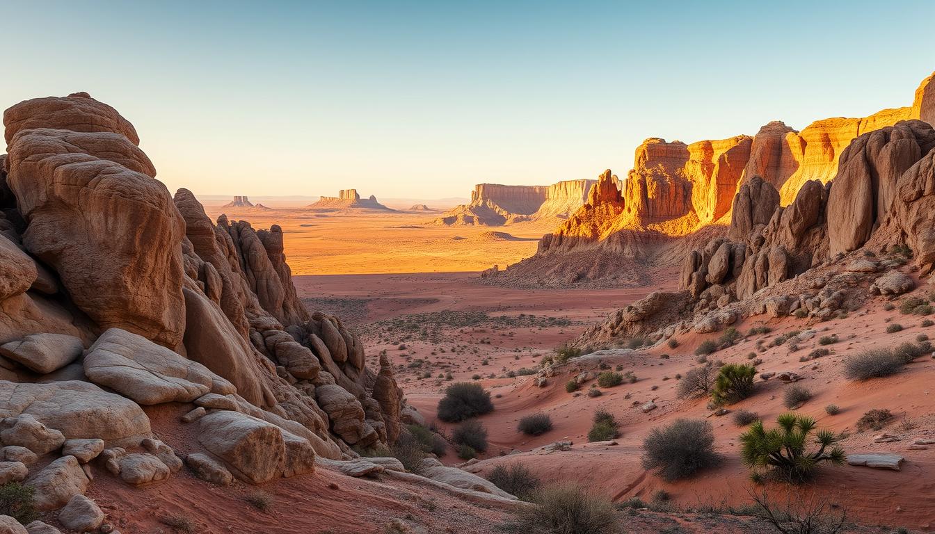
I arrived at dawn, keys warm in my hand, and felt like I had driven straight into another world. The first stretch of sculpted earth and wind-carved spires turned a simple road trip into a quiet lesson about scale and light.
This place sits near Tudela yet feels detached from everyday Spain. It is a UNESCO Biosphere Reserve of roughly 42,000–42,500 hectares, and its cinematic terrain has starred in big films and TV.
I planned a self-drive trip with early starts, flexible stops, and time to wait for the right light for photos. Marked entrances, a visitor center, and drivable dirt roads made exploration straightforward.
The hook was the silence. Canyons, eroded towers, and long loops—the 34 km circuit—shape a mood that invites patience. Along the route I met shepherds, noticed abandoned houses, and felt the human layer that deepens the geological story.
Key Takeaways
- Expect cinematic landscapes and quiet that change with light.
- UNESCO reserve spanning about 42,000–42,500 hectares.
- Close to Tudela; reachable by self-drive with marked routes.
- Visitor center, dirt roads, and a 34 km loop aid exploration.
- Bring time for photos and respect seasonal closures and safety.
Why I went to the bardenas reales desert and what I found
A lone image—an impossible blue door—became the small obsession that sent me to this place. That photo of La Porte des Anges felt like an invitation, even though the door no longer stands.
A first glimpse: silence, wind, and a landscape that feels off‑planet
On my first morning the wind spoke more than people did. The hush, the light, and the odd geology made me feel briefly like I had stepped off this world for a day.
I climbed the crumbled steps where the door once hung and felt how fragile the scene is. The absence of that blue portal made the whole story more honest.
“The place whispers rather than shouts; its gravity predates any TV fame.”
I expected Game of Thrones-era cameras and crowds, but the reserve held older layers: communal grazing rights dating to 882 and a fenced military zone used since the 1950s. Public areas remain peaceful.
My best photos came when I slowed, listened to the wind, and let the landscape set the pace. Solitude is part of the draw—visit outside peak months and the quiet deepens.
- I went for a door and found history, human traces, and raw vistas.
- The place rewards patience and attention to small moments.
- The rest of this article is a practical guide rooted in what I learned on the ground.
Where is Bardenas Reales in northern Spain and how to access the park
I found the park by following a single rural sign off the highway and watching the land open up.
Location and practical approach: The area sits in southeast Navarra, in northern Spain, roughly between Pamplona and Zaragoza and about 15–30 minutes from the town of Tudela. This makes it an easy day trip from the nearest city hubs.
Main entrances and routes: Arguedas vs. Carcastillo
Arguedas is the straightforward entrance with clear signage and parking. Carcastillo is quieter and better for sunrise runs. Both routes feed into Bardena Blanca, the most photographed core.
Visitor center, signage, and opening hours
The visitor center provides maps, toilets, and up-to-date route info. The park opens at 8:00 am and closes one hour before sunset. No night entry or camping is allowed.
Road conditions, speed limits, and driving a car or camper
Roads are mostly graded dirt but passable for a regular car with good clearance. Stick to the 40 km/h limit, watch for livestock, and download offline maps before you go.
- Arrive early to secure quiet points and parking.
- Respect parking etiquette at viewpoints and shoulders.
- Check seasonal advisories that may change access or close segments.
| Point | Arguedas | Carcastillo |
|---|---|---|
| Signage & parking | Strong signage, bigger lot | Smaller, quieter start |
| Best for | Easy access, daytime visitors | Sunrise, solitude |
| Leads to | Bardena Blanca core | Bardena Blanca core |
| Notes | Visitor center nearby | Close to El Paso area |
The story in the rocks: inland sea, erosion, and surreal formations
I remember tracing the layers with my eyes and realizing this ground once lay under a vast inland sea.
Millions of years ago the basin filled with water and fine sediments. Over time, sand, chalk, and silt settled in distinct bands. Uplift and an outlet to the Mediterranean drained that sea and left the layers exposed.
From sea basin to badlands: clay, chalk, and sandstone layers
The visible bands are literal pages of geological time. Soft clay and chalk sit beside firmer sandstone and conglomerates. These contrasts create the color stripes and crumbly textures you see.
Look for sediment lines at viewpoints; they explain how each layer formed and why some slopes crumble faster than others.
Why spires stand: hard caprock, soft slopes, and constant erosion
Spires survive when a resistant caprock shields weaker layers beneath. Rain and wind carve gullies and ridges, while the caps slow the process, so pinnacles can last for years.
Erosion is active today. Small gullies widen and loose clay slumps after heavy rains. That is why authorities forbid climbing fragile pinnacles: it endangers both people and the rock.
- I trace origin to an inland sea and layered sediments.
- I explain uplift, drainage, and the role of clay and sandstone.
- I stress that erosion reshapes features and that respectful viewing preserves them.
| Feature | Composition | Role in landscape |
|---|---|---|
| Top cap | Hard sandstone/conglomerate | Protects spire from rapid wear |
| Middle bands | Chalk and silt | Create color and break into ledges |
| Lower slopes | Clay and softer sand | Slip and erode, forming gullies |
“Knowing a place’s layers gives you a new way to read the land.”
History and land use add context. Communal grazing rights date to 882, and a marked military training area since the 1950s keeps visitors to safe corridors. Small bits of background information make on-site observation richer and safer.
Understanding the three areas: El Plano, Bardena Negra, Bardena Blanca
I learned to read the reserve like a map of moods—flat, wooded, then raw stone—each stretch with its own pace.
El Plano: flat trails, e-bikes, and birdlife
El Plano sits to the north and feels wide and gentle. Flat agricultural tracks make it perfect for e-bikes and family walks.
Birdwatching is rewarding here; migratory species use the open fields. Wear light shoes and bring water for easy day routes.
Bardena Negra: ridges, pines, and solitude
This southwest area shifts to shaded ridges and pine pockets. Trails turn steeper and rockier, so plan tougher hikes and sturdy boots.
People seeking quiet find solitude among the pines. Wildlife hides in the woodlands, and the mood is noticeably calmer than the core.
Bardena Blanca: the dramatic movie-set core
Bardena Blanca is the showstopper—the pale badlands, spires, and amphitheaters of erosion that draw most visitors to the bardenas reales.
Match your energy to the place: warm up in El Plano, test a ridge in Negra, and save Blanca for the best light and dramatic landscape photos.
- Each area has different trail types; adjust footwear and water accordingly.
- Signage thins beyond main tracks—download offline maps.
- Respect grazing livestock and the few people you meet on narrow paths.
Iconic viewpoints and rock formations you shouldn’t miss
I keep returning to particular viewpoints because they change so much with a single hour of light. From short walks I built a list of places that always repay the effort.
Castildetierra is the symbolic spire in La Blanca Baja and a top point for classic photos. El Rallón gives sweeping ridgeline views but note it is often closed Mar–Aug for nesting. La Ralla de la Negra marks the dramatic transition between pale badlands and darker ridges.
Other must-see points
Pisquerra offers sculpted ridges and an amphitheater feel that pops under side light. Scattered abandoned houses add eerie texture and human stories across the plain. Nearby, the Monument to the Shepherd is a quiet cultural waypoint worth a short stop.
Timing and tips: Aim for golden hour and remember the park closes one hour before sunset. Compose shots with cracked clay or ripple marks in the foreground to add depth. Carry a microfiber cloth for dust and a lens hood to control flare.
“Stick to marked paths near fragile formations to keep the landscape intact and safe.”
- Check El Rallón access before you hike.
- Use marked panoramic viewpoints near the military zone—they’re safe and well signed.
- Respect closures and return plans to meet the park’s closing time.
Best ways to explore: road trip loops, hikes, bikes, and guided tours
I timed my arrival to catch the park opening and watch the light reshape each viewpoint.
The 34 km circular route is the most efficient way to sample the Blanca core in a single day without rushing. The unpaved route suits a regular car; allow about 2–3 hours with stops for short walks and photos.
Start from Arguedas or Carcastillo for easiest access. Arrive right at opening for quieter pull-offs and the best light. Drive slowly—40 km/h—and expect livestock on narrow sections.

The 34 km circular route through the core
Plan hour-by-hour pacing: a slow first hour for early viewpoints, a second hour for trails and photos, and a final hour to return and chase late light. Mix driving with short trails to reach viewpoints the loop only hints at.
Segways, quads, dune buggies, horseback, and e-bikes
Guided options include 4×4 tours, quads, buggies, segways, horseback rides, and e-bike rentals. Guides add local stories, safety tips, and access to lesser-known viewpoints you might miss on your own.
“Good planning balances the loop’s structure with the freedom to chase light and explore side spurs.”
- I recommend the 34 km loop as the best way to see highlights in a single day.
- Bring offline maps and a printed copy as backup.
- Pack water, sun protection, and a light wind layer so you can extend spontaneous stops by an hour or two.
Wildlife and nature in a semi-desert biosphere reserve
I learned to wait quietly at a ridge and watch the sky for the slow sweep of raptors.
Griffon vultures are the most common overhead, riding thermals with a steady glide. Golden eagles and kestrels appear on clear days and feel like special rewards when they show. I keep binoculars handy to track flight patterns and calls.
Tracks often tell the reserve’s quieter stories. Wild boar hoofprints, fox pads, and badger digs show up along less-used trails. Sightings are rarer than prints, so I read the ground as much as the sky.
Small life fills the gaps. Lizards sun on warm rocks, butterflies cross gullies, and crickets erupt underfoot. Over 300 plant species survive here, including halophytes and wiry grasses that host a brief spring bloom.
Timing matters: heat and wind shape animal activity, so dawn and late afternoon offer the best windows for movement. Stay on paths to protect nests and fragile plants.
“Patience reveals the living world here—sit still and it comes into focus.”
- Bring compact binoculars and a field guide for better ID.
- Listen for wing beats and calls during calm moments.
- Learn a few local cues; they make sightings far more rewarding.
| Wildlife | Where to notice | Best time |
|---|---|---|
| Griffon vultures | Thermals above ridges | Dawn to midday |
| Golden eagles & kestrels | Open areas and cliff edges | Clear, calm days |
| Boar, foxes, badgers | Quiet tracks and scrub | Early morning & dusk |
| Plants & insects | Gullies, saline flats, spring meadows | Spring for blooms; warm days for insects |
I also found handy practical cycling the abandoned railway tips useful when planning varied days across nearby areas and routes.
When to go, weather, and seasonal restrictions
I timed visits around the weather app, because the heat and wind here change plans fast.
Summer can be harsh: temperatures often top 35°C, so the best months to visit run May–October with mornings the coolest time of day. I plan heavy outdoor activity early and keep midday for short stops or shaded breaks.
Park hours are fixed—open at 8:00 am and closing one hour before sunset—so arrive with time to spare and leave enough buffer to exit safely.
Summer heat, shoulder-season comfort, and rain advisories
Shoulder seasons offer milder time windows and fewer crowds. In peak summer I rise before dawn and use the first two hours for hikes and photos.
After consistent rain the unpaved roads turn slick and rutted. Authorities may advise postponing entry until conditions improve. I check road reports the night before and the morning of a visit.
Nesting closures, hunting periods, and official updates
Some areas close for nesting, often March–August, and occasional hunting periods can restrict routes. These protections reflect years of erosion and wildlife needs.
“Check official channels the day before and again the morning of your visit for the latest access notes.”
- Build a flexible day plan that can pivot if a trailhead is closed.
- Carry more water than you think you’ll need; facilities are limited inside the park.
- Watch wind forecasts—gusts affect dust and visibility on exposed ridges.
| Concern | What I do | Practical tip |
|---|---|---|
| Summer heat | Start early, limit midday exposure | Use dawn hours; short, shaded breaks at noon |
| Rain & roads | Delay visits after sustained rain | Check road advisories; avoid low-clearance vehicles |
| Nesting & hunting | Confirm closures before setting out | Follow signs; respect fenced boundaries |
| Water & supplies | Bring ample water and snacks | Know the last refill point before entry |
Practical tips for safety, access, and low-impact travel
My checklist starts with hydration and ends with a printed map in the glovebox. Inside the park facilities are scarce; the visitor center has toilets and information, but you should assume no services elsewhere.
Water, sun protection, footwear, and offline maps
Carry plenty of water per person, high-SPF sunscreen, a brimmed hat, and secure sunglasses. Pack heat-stable food and energy snacks since shade is limited and there are no food points inside.
Wear sturdy shoes for gravelly tracks and short scrambles. Bring a light wind layer for ridgelines.
Download offline maps and bring a printed route. A headlamp and small first-aid kit are smart additions.
Military boundaries, drones, and leave-no-trace
Respect clearly marked military zones; access is restricted and enforced. There is no camping or overnighting inside the park; camper aires are available in Arguedas and Carcastillo towns outside.
Drones are banned without a permit—don’t risk fines or disturbing wildlife. Pack out trash, avoid fragile crusts and slopes, and keep noise low.
“A well-maintained car, cautious driving, and basic supplies keep a great day from turning into a problem.”
| Need | What I do | Practical tip |
|---|---|---|
| Water & food | Bring plenty; heat-stable snacks | Refill before entry; pack extra |
| Driving & roads | Check tires, fuel, coolant | Keep 40 km/h, watch livestock and cyclists |
| Navigation | Offline maps + printed copy | Mark exit points and visitor center |
| Regulations | No camping; obey military signs | Get permits for drones if needed |
Where I stayed and smart bases near the park
I chose a small town as my launching point to keep mornings slow and the drives short.
My base: La Casita Azul in Cáseda
I based myself at La Casita Azul in Cáseda. The homestay works as a whole house or private rooms.
It felt lived-in and welcoming, perfect for families or groups who want to move slowly before heading to the park. For direct booking call +34 655 917 839.
Design stays and rural charm
Hotel Aire de Bardenas offers minimalist rooms and stargazing bubble options for a memorable night near the reserve.
Valtierra’s converted cave houses stay cool in summer and cozy the rest of the year. For more city choices, Tudela has hotels like Sercotel Tudela Bardenas and AC Hotel Ciudad de Tudela, plus plenty of food and lively plazas.
Camper tips and overnight rules
Overnighting inside the park is forbidden. Use the camper aires in Arguedas and Carcastillo, which have basic services and easy exits to town amenities.
Plan breakfasts or picnic food in town to catch opening hours and get the best light at viewpoints.
“Choosing the right base shaped my mornings — less driving, more time at the best places.”
| Type | Example | Best for |
|---|---|---|
| Homestay/house | La Casita Azul (Cáseda) | Families, slow mornings, self-catering |
| Design hotel | Hotel Aire de Bardenas | Stargazing, unique stays |
| Cave houses | Valtierra conversions | Atmosphere, cool summer stays |
| City hotels | Sercotel & AC Hotel (Tudela) | Restaurants, transport links |
Beyond the park: day trips that round out your Navarra road trip
From my base I sketched a set of day trips that folded the wild and the historic into neat, driveable loops. These places sit 15–60 minutes away, so each outing stays light and flexible.
Nature first: I recommend Irati Forest for mossy beech-and-fir paths, especially striking in autumn color. Urederra’s turquoise pools add a family-friendly water trail—book ahead in high season and budget about €3 for parking.
Gorges, castles, and a lively city
Lumbier’s rail-trail gorge is easy and great for vulture viewing; pair it with Arbayún for a fuller raptor day. Castillo de Javier offers hilltop drama and a compact museum for a short cultural stop. Olite’s royal palace pairs turret views with local wine tasting.
I finish a few days with Pamplona to taste pintxos, soak in plazas, and feel the Camino rhythm. This mix of forest, water, gorges, forts, and city time keeps the trip varied and manageable from one comfortable base.
“Pair nature days with history and city breaks to keep your energy and curiosity fresh.”
Conclusion
I learned quickly that an early start and patient driving unlock the park’s quiet moments and best photos.
The bardenas reales is a UNESCO reserve where texture and light shape every visit. Castildetierra and the 34 km core route remain the clearest draws, and marked entrances at Arguedas and Carcastillo make planning simple.
Practical rhythms matter: arrive near opening, obey the 40 km/h limits, and leave with the one hour before sunset rule in mind. Carry plenty of water, plan a nearby town as your base, and use camper aires if you need services.
Fold nearby stops—Irati, Urederra, Lumbier/Arbayún, Castillo de Javier, Olite, and Pamplona—into your road trip so the wider area becomes part of the story. Move with intention: the route you choose, the hour you pick, and the way you watch the rock and clay will define your trip.
Lascia un commento