
I remember stepping from the road into a wide, silent expanse that felt part Mars, part Monument Valley. This is my careful guide to the bardenas reales desert, a sculpted semi-arid region in southeast Navarra declared a UNESCO Biosphere Reserve in 2000.
I’ll set clear expectations for scale and access. The park spans about 41,845–42,000 hectares shaped by wind and water. Iconic formations like Castildetierra and Pisquerra punctuate a raw, photogenic landscape.
This guide is for road trippers, hikers, photographers, and solitude-seekers. I balance logistics with stories so you can plan routes, find viewpoints, and respect closures and military zones. Expect big skies, sparse plants, and a silence that changes how you move.
Practical notes: easy access via Arguedas and Carcastillo, a classic 34 km loop for regular cars, and daily open hours from 8:00 am to one hour before sunset. No night entry or camping—so come early and stay thoughtful.
Key Takeaways
- This place blends dramatic forms with easy road access for mindful visits.
- Allow time: the best light is early and the quiet rewards slow travel.
- Follow rules: marked military zones and no-camping hours protect visitors and nature.
- Bring basic gear: water, sun protection, and a reliable map for dirt roads.
- I mix practical tips and personal notes so you can plan confidently and still be surprised.
Why I fell for the Bardenas Reales Desert
The moment I first stepped beyond the road I felt the landscape breathe around me. The hush, the wide horizons, and a light that sculpts clay into impossible shapes hooked me right away.
I chased a story here once—a famous blue door called La Porte des Anges that has since vanished. That small loss made the place feel alive and ephemeral.
People still move through this land the old way. Shepherds follow routes that date to 882 and bring herds across in September during transhumance. That living rhythm gives the park a human pulse amid its silence.
Wind and water carved the ranges over time. You only believe the scale when you stand beneath the spires and feel small. Off-peak visits and golden hour turn clay and gypsum into glowing sculpture.
- I felt alone and connected at once—alone because of the scale, connected because of history.
- There’s a strange coexistence here: protected nature beside a marked military training zone. Boundaries are clear, so respect is simple.
- I return because each visit writes a new story in light and weather.
Bardenas Reales at a glance: biosphere reserve, size, and setting
I want you to picture the park’s scale before you drive in: wide plains and sculpted hills that feel larger than the map. This area is an official biosphere reserve since 2000 and sits in southeast Navarra, about 15 minutes from the nearest town near Tudela.
The protected natural park covers roughly 41,845 hectares (often rounded to 42,000 hectares). Soft clay and gypsum layers have been carved by erosion into ravines, cliffs, plateaus and mesa-like forms that reach up to roughly 600 m.
Practical points I rely on
- Opening hours: 8:00 am to one hour before sunset; no night entry or camping.
- Visitor Centre (Arguedas): Carretera del Parque Natural, km 6 (NA-8712, km 0.8). Email: turismo@bardenasreales.es. Phones: +34 948 820 020 / +34 948 830 308.
- Main access: Arguedas and Carcastillo; alternatives: Rada, El Paso, Virgen del Yugo depending on your loop.
- Watch for clearly marked military training zones and seasonal closures for nesting in places like El Rallón.
- Terrain and weather matter: tracks change after rain and wind shapes the landscape and your comfort.
Beyond geology, the park hosts hardy steppe species and a human history of shared grazing rights. I always start early for the light and to pick up current maps and road conditions at the Visitor Centre before heading into this unique landscape.
Getting there and getting around: access, roads, and the visitor center
Getting to the park is simple, but small choices change the whole day. From Tudela it’s about a 15-minute drive to the main entrance, so I often base myself in that town for quick access and extra services.
Main access points
I use Arguedas for first-time visits and direct entry to Bardena Blanca. Carcastillo is quieter and works well for sunrise starts.
- Alternates: Rada, El Paso (near the Monastery of La Oliva), and Virgen del Yugo for specific viewpoints or loop variations.
- The classic 34 km loop is unpaved but usually fine in dry weather for a regular car; drive slowly on washboards.
Visitor Centre and practical info
The Visitor Centre sits at Carretera del Parque Natural, km 6 (entrance from NA-8712 km 0.8). I always stop there for maps, current track advisories, and up-to-date information on closures.
- Fuel and supplies: fill up in town and carry water and snacks.
- Roads: expect graded dirt and compacted tracks; avoid muddy days and respect military signs.
- Rules: no night entry, no camping, and stay off signed restricted areas.
Understanding the three zones: El Plano, Bardena Negra, and Bardena Blanca
To navigate this area well I think in zones: flat plains, wooded ridges, and sculpted badlands. That layout helps me plan walking, biking, and photography without wasting time.
El Plano: flat plains, farm tracks, and easy e-bike terrain
El Plano is broad and calm. Farm tracks and open plains suit e-bikes and gentle walks. I use it to warm up, watch steppe birds, and save energy for rougher ground.
Bardena Negra: ridges, pine forests, and tougher hikes
Bardena Negra feels darker: richer soils, serrated ridges, and pine forests. I reach it from the Tudela–Ejea road toward Sancho Abarca. Trails here are steeper and give shade and solitude.
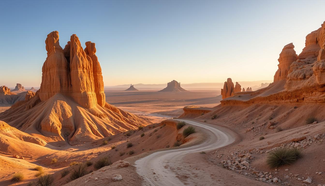
Bardena Blanca: eroded clay, gypsum, and the photogenic heart of the park
Bardena Blanca is the photogenic center. I sequence Castildetierra, Pisquerra, El Rallón, La Ralla, Raso de la Junta, Alto de Aguilares, and La Cruceta across an afternoon. The terrain is wind-exposed, rutted, and best timed for late light.
My pacing tip: warm up in El Plano, hike in the Negra’s shade, then save the Blanca for golden hour.
“Move with intention: quiet zones and fragile soils deserve respect.”
Iconic viewpoints and formations you shouldn’t miss
I pick viewpoints that reveal how wind and water carved the park’s best shapes. These landmark points show erosion at work and make for easy planning on a one-day route.
Castildetierra: the spire that defines the landscape
I approach Castildetierra early or late to capture shadow and texture. The rock spire sits on soft clay and glows with low sun.
Tip: keep well back from the base. The pillar is fragile and closed trails protect it.
Pisquerra: lunar ridges and sculpted badlands
Pisquerra is a maze of ridges and gullies shaped by erosion. Short walks here reward with big-sky panoramas and strong leading lines for photos.
El Rallón and La Ralla de la Negra: sweeping vistas and seasonal closures
The ridge-top views are wide and dramatic. Note: portions close for nesting roughly March through August. Respect closures to protect raptors and breeding birds.
Vedado de Eguaras and Peñaflor Castle ruins
Vedado de Eguaras is a greener cirque among gypsum ravines, with juniper and Aleppo pine. Peñaflor Castle perches above and makes an eerie contrast to the sculpted ground below.
“Watch thermals near high edges—griffon vultures and other raptors reward patient scanning.”
| Point | Why go | Access & time |
|---|---|---|
| Castildetierra | Iconic spire; best light early/late | Short walk; allow 30–60 min |
| Pisquerra | Ridges, gullies, strong lines for photos | Walks from parking; 45–90 min |
| El Rallón / La Ralla | Panoramic ridge views; nesting closures Mar–Aug | Drive + short hikes; 1–2 hrs |
| Vedado de Eguaras | Green cirque, gypsum ravines, Peñaflor ruins | Longer stop; combine with nearby viewpoints |
Practical route note: link Castildetierra, Pisquerra, and La Ralla in one loop. Pace your tour so you do not rush sunset photos.
Safety and gear: wear shoes for crumbly slopes and bring poles for dusty descents. Stay off fragile bases and obey barriers at all times.
Wildlife and biodiversity: vultures, steppe birds, and resilient flora
Wildlife arrives in small moments here—wings over a ridge, a flash of lizard on warm rock.
I watch ridge thermals for the raptor spectacle. About 24 birds of prey patrol the skies: griffon vultures, peregrine falcons, booted eagles, and the rarer Egyptian vulture. Patience near high edges often pays off.
Birds of prey and steppe species
Steppe life shows in flats and early mornings. Great bustards and larks move across open soil. I use a pair of binoculars and a bird app to confirm sightings.
Mammals, reptiles, and amphibians
More than 28 mammal species live here: boar, fox, and badger leave tracks I follow. Sunny rocks host ocellated lizards and ladder snakes. Near still water you may spot the Spanish pond turtle and small newts.
Plants of clay and gypsum
Vegetation adapts to salty flats and crumbly clay. Halophytes stud the plains, while Aleppo pine, juniper, and rosemary form green islands in pockets like Vedado de Eguaras.
“Even dry arroyos hold life—keep your eyes soft for subtle movement.”
| Group | Notable examples | Best time to see |
|---|---|---|
| Raptors | Griffon vulture, peregrine | Dawn–midday thermals |
| Steppe birds | Great bustard, lark | Early morning |
| Reptiles & amphibians | Ocellated lizard, pond turtle | Warm, sunny spots; near water |
| Mammals | Boar, fox, badger | Tracks at dusk or dawn |
Respectful viewing: keep distance in nesting season, carry out trash, and never approach water sources used by wildlife. This small care keeps the place healthy for visitors and species alike.
Best routes and activities: my favorite ways to explore
I usually plan routes by light and wind, because timing changes everything on the clay plains.
The classic 34 km Bardena Blanca driving loop is unpaved but friendly to a regular car. I allow 2–3 hours with photo stops. Expect ribbed surfaces in places and dusty stretches; I pull over where there is safe visibility to avoid dust plumes.
The half-day on foot: key short hikes
I link Alto de Aguilares, La Cruceta, and Raso de la Junta in a relaxed half-day. Start at sunrise or late afternoon to soften light and reduce heat. Build in buffer time—there’s always one more photo or a better angle.
Guided tours: which to choose
Local operators run 4×4 tours for reach, quads and buggies for adrenaline, horse rides for slow pacing, and Segway or e-bike tours for fun on flatter tracks. I pick a tour based on weather, access, and how close I want to get to sensitive areas.
Cycling and e-bikes
Go gravel-ready or choose an e-bike. Start wind-aware, carry extra water, and avoid loose ridges in gusts. Over 700 km of back roads crisscross the wider area—good for longer rides when conditions are right.
“Leave margins: dirt slows you down and views make you stop.”
| Activity | Best for | Typical time | Notes |
|---|---|---|---|
| 34 km driving loop | Photography, easy access | 2–3 hrs | Regular car suitable; watch for ribbed surfaces |
| Short hikes | Alto de Aguilares, La Cruceta, Raso | Half-day | Start at sunrise/late afternoon; pack water |
| Guided tours | 4×4, quad, buggy, horse, Segway | 2–4 hrs | Choose by weather and desired reach |
| Cycling / e-bike | Gravel riders, e-bike explorers | 2+ hrs | Wind-aware planning; extra water and spares |
My routine: check Visitor Centre updates for access and closures before heading out. Keep a Plan B—if bardena blanca or bardena negra edges get windy or crowded, I pivot to El Plano or quieter margins of the park.
Game of Thrones in the Bardenas Reales
Filmmakers used this park’s empty horizons to sell otherworldly backdrops with startling ease. The show leaned on the Bardena Blanca badlands to suggest distant realms, thanks to stark textures and wide, uncluttered sky.
Where it looks most cinematic:
- Castildetierra — the spire reads like a lone outpost when framed low with foreground rock.
- Pisquerra — ridges and gullies form natural leading lines for dramatic shots.
I map a simple self-drive plan: hit the obvious filming viewpoints early, then turn down quieter tracks for pace and privacy. This balances photo stops with quieter places where the land feels less staged.
Local operators run themed tours if you want lore and efficient routing. A guided tour can add behind-the-scenes anecdotes and save navigation time.
On etiquette: stay on tracks, don’t climb fragile spires, and avoid blocking narrow pullouts during long photos. Respect keeps these set-like places intact.
Timing tip: shoot at sunrise or late afternoon to soften shadows and avoid heat on long stops. Always check access and seasonal closures before chasing shots around ridges.
“Pop-culture hooks are useful—then put the camera down and listen. The deeper story is the land itself.”
Where I stay near the park: from homestays to design bubbles
I pick a base not by luxury but by how fast I can reach first light in the park. My choices balance early departures, parking, and a comfortable place to sort gear.
La Casita Azul — Cáseda
La Casita Azul feels like a real home. You can book a room or the whole house and enjoy strong Wi‑Fi and helpful local people. For booking information contact Steve at +34 655 917 839.
Hotel Aire de Bardenas
This design-forward place is a memorable stay. Minimalist rooms and glass bubble suites are a neat way to chase stars and quiet landscapes.
Cave houses in Valtierra & Tudela hotels
Valtierra’s cave houses stay cool in summer and cozy in winter—great for families. In town, Tudela hotels (like Hotel Sercotel Tudela Bardenas and AC Hotel Ciudad de Tudela) offer walkable evenings and easy access to restaurants.
Trip strategy: I often split stays: one night near Arguedas/Valtierra for pre‑dawn access, then a couple nights in Tudela to enjoy food and culture.
| Base | Why I pick it | Travel note |
|---|---|---|
| La Casita Azul (Cáseda) | Warm hosts, Wi‑Fi, road‑trip hub | Short drive by car to park; good parking |
| Hotel Aire de Bardenas | Design stay, stargazing bubbles | Best for a unique place and photo nights |
| Valtierra / Tudela | Cave comfort or town amenities | Easy way to balance early starts and evening city life |
“Book early in peak months if you want bubble rooms or specific caves.”
Practical tips: safety, packing, and desert sense
I plan each visit around three priorities: safety, light, and a small, reliable kit. These make messing about on back roads and ridges easier and safer. Park rules are clear: open 8:00 am until one hour before sunset, no night entry and no camping. The Visitor Centre on NA-8712 gives current maps and updates.
Water, sun, layers, and footwear
My packing rule: at least 2 liters of water per person and more for long hikes or heat. I add high-SPF sunscreen, a brimmed hat, and UV-rated sunglasses.
I dress in layers for cool mornings, hot middays, and windy afternoons. I carry a light wind shell and a spare midlayer in the car. Sturdy shoes or boots with good tread are non-negotiable; poles help on dusty slopes.
Navigation, drones, and marked military areas
I rely on offline maps plus a paper backup. Cell coverage drops away from main tracks, so download routes before you leave. Drones need permits and many zones are off-limits; I usually leave mine at home and shoot from the ground.
Safety: respect clearly marked military areas and closures (El Rallón/La Ralla close roughly March–August for nesting). Never cross barriers at fragile points.
Best time to visit and photography light
I time visits for golden hour—start early for soft shadows, save late afternoon for glow. Midday is best for exploring shaded Bardena Negra points or longer drives in the car.
“Drive slowly on dirt roads, yield on blind corners, and always leave no trace.”

- Pack snacks, a compact first aid kit, headlamp for pre-dawn prep, and a trash bag.
- Check forecasts—rain can slick tracks and strong wind makes ridgelines unsafe.
- Drive patiently and choose routes with safe access and clear pullouts.
Conclusion
A single road can turn into an entire day of discovery if you let it slow you down.
I keep coming back to the bardenas reales desert because the protected biosphere reserve—some 41,845 hectares—feels both timeless and alive. Start early, drive the classic route, and step out often to feel the space rather than just see it.
Use nearby towns like Tudela, Arguedas, or Valtierra for logistics. Respect marked military zones and opening hours. Give wildlife, especially soaring vultures, the distance they need.
Pick a season that fits your style, save quieter corners with the obvious places, and call the Visitor Centre for up-to-date information. Pack water, clear your camera, download an offline map, and go with an open way of seeing.
Come once to understand why I return—silence here changes how you travel.
Lascia un commento