
I first heard the nickname the “Village of Two Lies” while leafing through a travel notebook. The name sounded like a dare. It promised contradiction: no fountain, no beauty, yet a place that would not let me leave my thoughts untouched.
At the heart of Soria’s Sierra de Alcarama, I found a compact landscape that told a longer story. Dirt tracks kept people connected only loosely to nearby towns, and through the 20th century that isolation pushed many to leave.
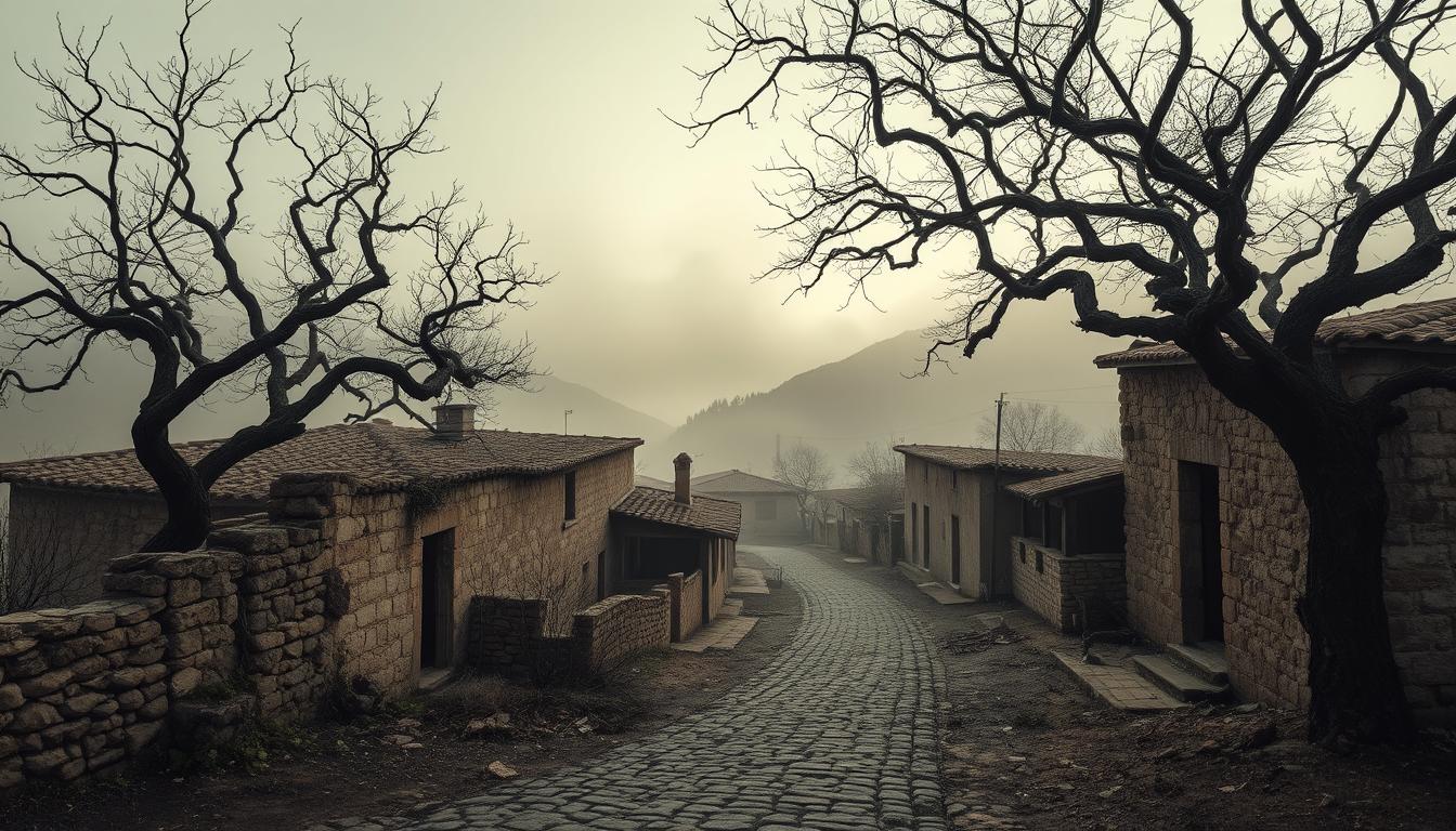
The area now lies quiet, with ruined houses, a ruined church and pines reclaiming roofs. I walked the slopes at coordinates 42.03306, -2.15500 and listened for clues about time and how modern life reshaped this corner of Spain.
This article guides you through my on-site walk, a concise history from the 19th to the late 20th century, and practical notes for respectful visitors. I aim to show how one small place reflects wider patterns in the world and in local life.
Key Takeaways
- I was drawn by the paradoxical name and stayed for the stark, honest landscape.
- The site sits in Sierra de Alcarama and illustrates rural depopulation in Spain.
- Access was limited to dirt routes, which shaped why people left over time.
- Ruins, reforested slopes, and a ruined church mark the present-day area.
- The article offers history, an on-the-ground walk, and safety tips for visitors.
Arriving in Soria’s Sierra de Alcarama: my first look at the “Village of Two Lies”
I reached the final dirt track as the road thinned and the pines opened onto a patchwork of stone and shadow.
The last few minutes on the way set the tone: ruts that slowed my pace, a single narrow track into the area, and then the low line of collapsed roofs. One part of the landscape felt deliberate—terraces and shepherd paths that showed how people worked this land for years.
The nickname “Village of Two Lies” landed like a wink. On the ground it read as local humor and as a hint about how harsh time had been here. The church tower stood as proof that a community once gathered.
“The track dictated what arrived and what never did — goods, news, and the slow drift of younger hands away.”
- I used old wall lines and collapsed beams to orient myself.
- North-facing slopes keep shade and moisture; reforestation now hides many plots.
- Track conditions explained why access shaped daily life and decline.
| Feature | Observation | Implication |
|---|---|---|
| Access | Dirt track, narrow ruts | Limited goods and slow travel |
| Buildings | Tumbled walls, roofless rooms | Long abandonment, exposure to weather |
| Landscape | North-facing slopes, pines | Hidden ruins, moist shade |
From fountains to forestry: Fuentebella’s history and why it emptied out
Records and local jokes reveal why the place earned its mocking name long before the last roofs fell. The “Two Lies” moniker pointed at two simple facts: no communal fountain and a landscape many called plain rather than pretty.

What’s in a name
The nickname grew from dry wells and hard terrain. Locals used it as a wry claim that cut through small-town pride. It tells you how weather and scarce water shaped daily life and the community’s outlook.
Life across the 19th and 20th centuries
After the Old Regime fell this place became a constitutional municipality in Old Castile’s Ágreda district. In 1842 a census recorded 40 homes and 158 residents. By the early 20th century the population rose to about 200, mostly shepherds who tended goats and sheep.
The Church of Santiago Apóstol anchored rites and fêtes. Its interior arches, tower and bell marked time. On July 25 and in September people shared a communal meal—often a sheep—and visitors drank zurracapote.
Depopulation, ICONA, and final departures
Hard winters, no vehicular access, and isolation began to thin the population in mid-century. By the end of the 20th century there were roughly 135 inhabitants and only 34 houses left.
In the 1960s the government via ICONA bought land for reforestation, shifting incentives away from grazing and accelerating departures. The last families left in the 1970s, and in 1978 the site was incorporated into San Pedro Manrique, closing its municipal chapter.
“Work, weather and changing land policy together reshaped what people could do here.”
fuentebella ghost village today: coordinates, access, and its place in La España Vacía
On my GPS the spot registered clearly, but on the ground the houses hide under brush and saplings. I recorded the coordinates — 42.03306, -2.15500 — and followed a narrow dirt track that still shapes who comes and who stays away.
On the ground: 42.03306, -2.15500 and the dirt-track way in
The last miles demand sturdy boots, an early start, and GPS loaded in advance. The access way is unpaved and steep in places. Hikers can reach the site publicly, but lanes are faint and overgrowth hides many doorways.
Soria in context: population shifts from Calatañazor to Sárnago
This area is part of La España Vacía. Since the 20th century the north and interior lost population to cities during industrial growth and later crises. By 2020, 70% of Spain was under-populated and 53% at risk.
“Every collapsed lintel felt like a family story left mid-sentence.”
| Feature | Current state | Notes |
|---|---|---|
| Coordinates | 42.03306, -2.15500 | Exact spot for visitors |
| Access | Dirt track | Requires GPS and boots |
| Policy | Broadband, grants, incentives | Government programs aim to revive small towns |
- I saw roofless rooms and saplings growing through thresholds.
- National government measures now offer small grants and infrastructure plans.
- The place reads as a small, lingering layer of the modern world where memories return each summer.
Conclusion
, Paths, lintels and a lone bell tower still mark choices that shaped who stayed and who left.
I close this article by noting how a quiet village can show the push toward cities and the decisions people made across decades.
The residents and inhabitants left houses, a church, and lanes that map the town even after years of brush and weather.
Visit lightly: follow dirt tracks, respect ruins, and support nearby cafes and local groups who keep community life alive.
Policy moves like grants and rural broadband help, but lasting change needs services, transport and real work to anchor families.
In the end, the place endures in stories. My hope is that careful visits keep those stories part of the next century’s memory.
Lascia un commento