
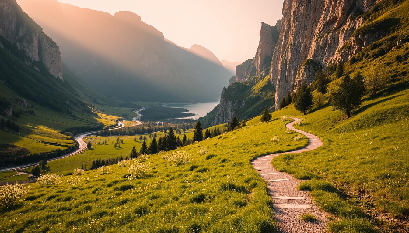
I first walked this long limestone valley on an early summer morning, when the light hit the cliff faces and the air smelled of pine. I moved slowly, like a quiet visitor, letting waterfalls and bird calls set the pace.
The route felt ancient — a corridor carved by glaciers with deep walls, lush forests below, and grassy heights above. I started on the canyon floor and kept my plan simple: follow the bottom path, pause for the views, then pick a balcony or rim option as the day allowed.
I note practical things up front: the national park gets busy, weather can flip fast, and snow clings high into July. My guide shows how to choose easy sections, when to climb toward Monte Perdido, and how to keep the walk calm and respectful of the place.
Key Takeaways
- Expect a long glacial valley with dramatic rock walls and mixed forests.
- Start on the canyon floor and choose balcony or rim routes to gain height.
- Plan for crowded refuges, changing weather, and lingering snow.
- Pace your day to enjoy the views and preserve the quiet.
- My guide outlines gear, timing, and safety steps for a calm passage.
Why I chose the Ordesa Canyon pilgrim trail for a serene, historic Pyrenees walk
I chose the path here to find calm stretches where the river and wind dominate the soundscape. I move at a contemplative pace, listening for bird calls and the soft rasp of pine needles underfoot.
The national park blends mixed deciduous woodland, pine stands, and high grasslands with wildlife like chamois. That variety lets me pick quieter lines away from busy day-walk sections.
Booking matters: Refugio de Góriz fills fast in high summer, so I book ahead or plan overnights that avoid the busiest hut. I favor shoulder-season windows and early starts to reduce crowds.
- I use balcony paths and lesser-used tracks to step off the main route while staying tied to the valley narrative.
- I respect camping rules and keep my footprint small to protect soils and plants.
| Feature | Why it matters | My approach | Notes |
|---|---|---|---|
| Refuge capacity | High summer crowds | Book early or skip | Often full in July–Aug |
| Vegetation zones | Scenic variety | Choose quieter belt | Deciduous to alpine |
| Camping rules | Protects soils | Camp only in allowed zones | Follow park regulations |
Trail snapshot: maps, distance, elevation gain, and wayfinding at present
A clear snapshot helps: the GR11 follows the valley bottom from Pradera de Ordesa to the head waterfall — about 8 km one way with easy-ish grades that let most parties reach the falls in a day.
I note the final push above the waterfall adds roughly 2 km of steep steps to Refugio de Góriz. Progress slows there, so I pace snacks and water for that climb.
GR11 on the valley floor vs. balcony faja options
The GR11 is broad and forgiving along the bottom. It suits steady walkers and offers easy bail options to the road or car park if weather turns.
The balcony fajas, like Faja de Pelay, are longer and more committing. Faja de Pelay has about an 8 km balcony segment and a steep 600 m ascent/descent to the valley floor. These sections need sure footing and a steady pace.
Navigation apps and markings I use
I load Spain’s Mapas de España maps and store a GPX on my phone as a backup. Offline GPX means I can confirm my position when clouds roll in.
Red-and-white blazes mark most lines. I read the terrain and follow blazes together, not relying on a single source.
| Segment | Distance | Notes |
|---|---|---|
| Pradera de Ordesa → Head waterfall (GR11) | 8 km | Easy grades, good for a day out |
| Head waterfall → Refugio de Góriz | ~2 km | Steep steps; slower progress |
| Faja de Pelay (balcony) | ~8 km (balcony) + 600 m ascent/descent | Exposed in parts; requires steady footing |
- I watch common social spurs and decide whether to explore or stay on the main route based on time and conditions.
- Download a clean GPX for trails Ordesa before arrival and cross-check it with Mapas de España.
- Keep the day flexible: the valley path lets you bail sooner; balcony lines often commit you further along the ridge.
When to go: seasons, storms, snow, and ideal day length
I plan outings to bank morning hours, knowing storms often form by midday. In the heart of the national park, summer and early fall give the best combination of light and warmth.
Expect mainly clear days in summer and early autumn, but severe thunderstorms can build fast. If clouds tower by late morning, I treat that as a hard sign to head low and off exposed ridges.
Summer and early fall: gorgeous skies, but quick storms
- Start early: I move at first light to bank time before typical afternoon cells.
- Turn-around times: I set conservative deadlines for exposed sections and stick to them.
- Flexible goals: If thunder appears, I switch to lower routes that keep the day safe and rewarding.
Snow timeline and higher ground
High slopes often hold snow late into the season. I treat mid-July onward as the more reliable window for higher ground near monte perdido.
“I build my days around weather shifts — if snow or storm cells say no, I pick a lower, scenic option and enjoy it.”
| Season | Typical weather | What I do |
|---|---|---|
| Late spring–early July | Lingering snow at altitude; variable | Bring traction, ice axe; avoid high rims if recent snow |
| Mid-July–September | Mostly clear mornings; common afternoon storms | Early starts, strict turn-around times, prefer valley options if clouds build |
| October | Cooler days, stable skies but shorter daylight | Plan shorter days, check forecasts for sudden systems |
Access and start points: Torla-Ordesa, shuttle to Pradera de Ordesa, parking tips
My plan starts in Torla, where the shuttle to Pradera de Ordesa sets the day’s rhythm. I base myself near town to avoid a last-minute parking scramble and take the bus into the national park.
Pradera de Ordesa trailhead: facilities and first waterfalls
Pradera de Ordesa is the main place to begin. There is a toilet at the trailhead and a wide, well-maintained path that follows Río Arazas. The river brings several waterfalls within the first hour, so I pace photos to avoid bottlenecks.
- I park near Torla and ride the shuttle to Pradera de Ordesa to skip parking stress.
- I allow time at the trailhead for a quick restroom stop and a final gear check.
- I plan my first hour around the waterfalls along Río Arazas and keep photo stops brief when it is busy.
- The lower valley path is broad and family-friendly—a good place to settle into the day before gradients rise.
- I watch shuttle schedules and aim for the first departures to reach the head of the valley in quieter light.
- I carry enough water from the start and verify fountain access in advance.
- I use the trailhead as a last weather checkpoint and adjust objectives if clouds build.
Starting this way saves time and keeps my focus on the walk. If I plan to push toward Monte Perdido, leaving Torla early gives me a lot more margin in changing weather inside the valley.
ordesa canyon pilgrim trail: my step-by-step route from valley floor to Refugio Góriz
From the valley floor I follow the Río Arazas, using the easy first kilometers to find a steady rhythm. The GR11 runs about 8 km from La Pradera to the great waterfall, with gentle grades and several cascades that make for pleasant stops.

Río Arazas and waterfalls to Cola de Caballo
I use the bottom path to warm up and enjoy the waterfalls. This section is forgiving and offers wide views of the valley walls. I take a short snack break at the head waterfall and check water and layers before the climb.
Ascent options to Góriz: switchbacks vs steeper sections
I usually pick the longer switchbacks to refugio goriz rather than the near-vertical shortcut. The switchbacks save energy and reduce exposure on loose rocks. If I do choose the steeper way, I move slowly and watch for rockfall.
Elevation gain, time, and view breaks
Count on roughly 13 km one way to refugio goriz with about 840 m of elevation gain. I plan 5–6 hours to reach the hut, allowing two view breaks where Monte Perdido unfolds below.
“I leave room to turn back early if clouds build; safe decisions keep the day rewarding.”
- I watch red-and-white blazes through the rocky upper section.
- I carry microspikes in early season for small snow patches.
- I space my group on steep pitches to avoid loose rock hazards.
Balcony paths and rim routes: Faja de Pelay, Faja de las Flores, and more
Balcony lines carve narrow ribbons below the cliffs, offering airy perspectives that change with every turn.
Faja de Pelay traces an extraordinary balcony for about 8 km with an approximately 600 m ascent or descent to the valley floor. I often link it into a loop, timing the long traverse and saving energy for the steep down-and-up section. A measured pace here pays off.
Faja de las Flores is spectacular and exposed—about 16 km with roughly 1,150 m of ascent and a 9–10 hour commitment. It includes two sets of clavijas and very exposed chains. I only attempt faja las flores in dry rock and stable forecasts, with early starts. If the chain descent feels wrong, I am ready to reverse.
Faja de Racón (≈11 km, 580 m ascent) and Canarellos sit under the northern cliffs with sharp rock on one side and layered vegetation on the other. I pick Racón when I want big walls up close and softer forest underfoot.
- I space my party at clavijas and keep three points of contact on narrow path segments.
- I use poles for balance and micro-traction when needed.
- These routes offer some of the best views back toward monte perdido and the ordesa valley—ideal for photographers who like airy perspectives.
“I never commit to las flores if storms are possible; a safe turn is the right decision.”
Summits and extensions: Monte Perdido, Punta Tobacor, and cross-border links
The upper massif rewards patience: I plan climbs that begin well before sunrise to catch firm rock and calm winds.
Monte Perdido from Refugio de Góriz is a tough but magnificent ascent. I start in the dark, carry extra layers for wind, and expect scree and limestone steps that demand careful footwork.
Rim circuits and nearby peaks
I favor Punta Tobacor for a quieter rim circuit with wide horizons and rolling highs. The route feels like a day among peaks rather than a single summit push.
Pico de Enmedio is a shorter peak I link when time is tight. It gives satisfying views back into the main valley and a simple exit if weather forces a quicker descent.
Cross-border links and longer routes
From Góriz I map an extension toward Lago and Refuge Tucarroya, then across into France to Refuge des Espuguettes and the Cirque de Gavarnie. These options make for multi-day moves between mountain huts and green valleys.
- Start early: firm rock and calmer winds on long ascents.
- Water and melt: carry extra water; seasonal melt near high basins is reliable in summer.
- Turnaround points: set conservative times on loose ground and steep rock bands.
“I judge descent lines before committing upward; a safe exit keeps the day rewarding.”
Safety and terrain: rock bands, loose gravel, waterfalls, and rapid weather shifts
I treat exposed sections as decision points, checking wind, footing, and my group’s mood before each move. I read the ground and mark escape lines on my map as I climb so I know where to go if conditions change.
Clavijas, chains, and knowing when to turn around
Faja de las Flores includes steep ascents with two sets of clavijas and an exposed chain traverse on the traditional descent. Many hikers choose to reverse the route rather than descend the chain.
My rule: if I feel rushed, if wind picks up, or if the rock is wet on a traverse, I turn back before committing to iron fittings. I space my group on steeper rock bands to reduce rockfall risk and communicate clearly before passing.
Thunderstorm protocol: immediate descent from exposed areas
I scan the sky constantly in summer. If thunder is audible, I’m already heading down. When towering cumulus appears near noon, I move off ridges, balconies, and high points.
- Keep metal gear stowed; avoid lone summits during cells.
- Choose the valley or forest as refuge if nearby storms fire up.
- Carry a lightweight shelter, headlamp, and an offline map app to avoid poor decisions under time pressure.
“I define red lines with exposure and stick to them—safety beats summit views every time.”
Where I stay: Refugio Góriz, mountain huts, and camping regulations
My overnight plan starts with booking and ends with an exit strategy. High-country accommodation centers on refuges and very limited camping. That means I aim to secure a spot early and carry a clear backup.
Refugio Góriz logistics
Refugio Góriz is the busiest mountain hut in the range, so I reserve well ahead for peak weekends. The refuge offers food, drinks, and basic facilities; expect queues in high summer.
I pack extra snacks in case dinner timings or hut capacity change. I also carry a small liner and check payment methods before I arrive.
Camping rules and etiquette
Camping inside the national park is restricted. I only camp above 2,100 meters or in the designated shelter zones near refuges.
I follow leave-no-trace rules and use durable surfaces. This keeps the privilege in place for everyone who follows the rules.
“I reserve Refugio Góriz early, keep a backup plan, and camp only where the park allows.”
- I reserve Góriz well in advance and carry a backup plan if dates shift.
- I plan meals assuming I may use a hut dinner, but I still bring calories and snacks.
- In summer I enjoy the social side of the mountain hut, then leave before dawn to regain quiet.
- I obey the camping rule: only above 2,100 m and near approved refuges, always on durable ground.
- I choose a sleep system for shoulder seasons to ensure warmth and quick recovery.
| Option | What to expect | My tip |
|---|---|---|
| Refugio Góriz | Food, drinks, bunks, busiest hut in the area | Book early; bring a liner; plan for lines in summer |
| Mountain hut (other) | Simple services; variable opening dates | Check opening periods and payment methods in advance |
| Camping (allowed zones) | Only above 2,100 m and near refuges; minimal impact required | Use durable surfaces; carry out all waste |
Sample itineraries: day hike, overnighter, and a quiet 3-6 day pilgrim-style loop
My itineraries focus on clear decision points and comfortable pacing for every party. I give a simple day option, a classic overnighter, and a longer loop that links Spanish and French huts.
Day option
Mellow: start at Pradera Ordesa, follow the valley to Cola de Caballo and return the same way for an easy, photo-friendly outing.
Bigger day: push to Refugio Goriz, refuel, and return via Faja de Pelay only in steady weather. This route adds exposure and a longer balcony finish.
Overnighter
Reach Refugio Goriz by afternoon, sleep in a mountain hut, and wake for sunrise toward Monte Perdido. The extra rest makes the return much easier the next day.
Multi-day loop
Link Goriz to Tucarroya, descend to Lago and cross to Refuge des Espuguettes, then head toward Bujaruelo. Add a Pineta Valley detour if you have extra time.
“I match daily elevation gain and exposure to my group’s comfort; a wrong descent late in the day costs a lot of energy.”
| Itinerary | Distance/Notes | Why choose it |
|---|---|---|
| Day (valley) | 8–16 km; low exposure | Easy photos, steady pace |
| Overnighter | ~13 km to Goriz; 840 m gain | Sunrise views, lighter pack next day |
| 3–6 day loop | Multi-stage; huts en route | Quiet sections, mixed terrain |
Conclusion
I finish by underlining how a clear plan and a flexible mindset turn big days into steady, rewarding ones. The GR11 along the valley floor gives a reliable backbone, with balcony lines, rim routes, and summits like Monte Perdido waiting as extensions.
Severe summer thunderstorms can appear fast, and the high range usually clears of snow by mid‑July. Start early, read the sky, and choose a route that matches conditions and energy.
Respect the land: stay on the path, pack out your waste, and leave the valley quieter than you found it. With smart decisions, a single luminous day or a longer move toward Mont Perdu will stay safe and memorable.
Lascia un commento